
A huge winter storm is on the way starting Thursday morning and lasting into Sunday morning.
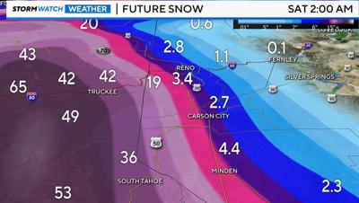
The mountains will see 3-5 feet of snow in the higher elevations and 2 to 3 feet of snow at Lake Tahoe Thursday through Sunday morning.
Our valleys will have strong winds on Thursday, 50 to 60+mph with rain and snow showers Friday morning switching to all snow by Saturday morning with 6-18" of snow possible around Reno and our valleys through early Sunday morning.
Here are cross-sections showing expected snowfall over Sierra passes via I-80, US-50, and NV-431. 🚗❄
— NWS Reno (@NWSReno) February 27, 2024
Heavy snowfall is expected to all elevations. To reiterate, travel in the Sierra between Thursday-Sunday will be extremely dangerous if not impossible. #nvwx #cawx pic.twitter.com/4jh9VCHAw8
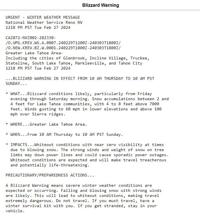
NWS Reno has issued a blizzard warning for Thursday, which you can read below.
The storm begins to move out on Sunday but plan on major travel delays and road closures in the mountains this weekend, travel is not advised.
A winter storm watch is up for the Sierra Nevada Mountains from late Wednesday night through Sunday morning.
A high wind watch is up for Reno and our valleys from late Wednesday night through Thursday evening with 50 to 60+ mph winds possible. Be prepared for downed trees and power lines.
Pack an emergency survival kit for your car in case you get stranded during the storm.
Check www.nvroads.com for the latest road conditions.