*****Storm update******
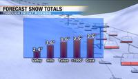
The Winter Weather Advisory still goes through 10am Friday for the valley. I am expecting a little more snow though. Totals will range from 2-4 inches in the valley to three to six inches in the hills. Snow is still possible in the Sierra, with a few more inches possible there. Fernley, Fallon, and Dayton will see a few inches as well. Majority of Friday will be dry, with some melting. If you have any travel plans Friday after 10am would be your best bet. Another storm arrives in the Sierra late Saturday.


****Original Post*****
It’s been a busy week for travel in the Sierra with heavy snow continuing to fall at times Wednesday night. The front has already made its way south of Highway 50, but the upper level low remains. The low will keep the air unsettled and cold. Travel is still not advised in the Sierra, but it should improve slowly with Friday being a good travel day. In the meantime, bands of snow showers will continue to rotate around the low.

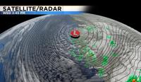
The low actually broke a record along the west coast with a pressure of 973.4mb by the time it hit the California coastline yesterday. The pressure dropped 43mbs in 24 hours. In order for a low pressure system to bomb out it has to lower at least one mb for every hour. The lower the pressure the stronger the storm typically is. Not only did the storm bring heavy snow to the Sierra but it also produced strong winds and heavy rain along the west coast.

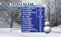
The Sierra got a good amount of snow as of Wednesday morning with more falling as I type this. An additional foot could fall by Friday morning. The valley did not get much snow because temperatures were just a tad too warm. We did get nearly a tenth of an inch of rain at the airport. By the time temperatures were cold enough for snow in Reno the band was out of here. The front may have stalled out last evening which kept temperatures warmer south of the front. While to the north of the front and north of I80 was cold enough for snow. By the time the front pulled away there wasn’t much precipitation left to give in the Reno area.

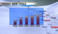
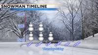
Lake effect snow is possible Wednesday night into Thanksgiving morning. This could bring a dusting to a few inches of snow to Carson City, Washoe Valley, and southwest Reno. There is also a chance for light valley snow Thursday evening into Friday morning as more bands rotate around the low. The snow could also be enhanced by Lake Tahoe and Pyramid.

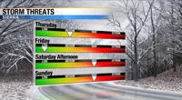
Friday after 10am, is the best travel day with another storm impacting the area late Saturday through Monday. This one will bring heavy snow to the Sierra and a mix of rain and snow to the valley. Have a good Thanksgiving.