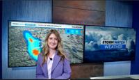
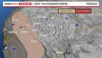
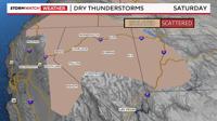
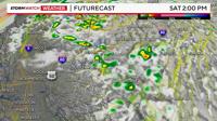
Sunday will be better than Saturday for the outdoors, because of thunderstorms. Most of the storms will develop in the Sierra Friday, before marching northward early Saturday morning. Reno has a 20% chance for showers and thunderstorms on Friday, increasing to 40% by 3am Saturday morning. It won’t be raining the entire time on Saturday, but it will here and there. The showers will be scattered and fast movers.

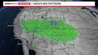
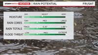
High pressure is centered to our east over the four corners, allowing for clockwise flow to pump moisture towards the Truckee Meadows. Most of the moisture is sitting in the mid levels of the atmosphere, with drier air at the surface. This means that dry lightning is possible. Rain is likely, but the trick is to get the rain lined up perfectly with the lightning. The jet stream will enhance the speed of the storms, not giving them a ton of time to saturate and gather moisture. Rain cores will be present, but not huge. The bigger the rain core, the less likely a fire will start. A shortwave will also travel north into California Friday afternoon, giving the storms more lift.


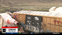
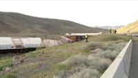
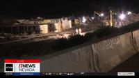
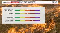
Gusty winds, small hail, frequent lightning, fire starts, and flooding over burn scars are possible with any storms that do develop. Overall, the flooding threat is low in the valley, but burn scars will be something to watch. Dry lightning is also possible, but it will be isolated to spotty.

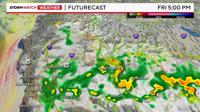
Usually, storms develop in the afternoon, but overnight storms are possible this go around too. As the ridge moves east Saturday, the storms will change direction as well. With a southeasterly flow, most of the storms will skip the Truckee Meadows on Friday, but as the flow comes more out of the southwest, storms will be able to develop in the Reno area much easier early Saturday.

Rain totals will vary within town, with some people not getting anything. This is the setup where some of us could get nothing, and others could get over a tenth of an inch. I’m not expecting as much rain as what fell last week, but if you get underneath a strong storm, you could pick up close to a quarter of an inch within a hour. Rain rates will be higher in the Sierra where the shortwave is moving through. Sunday will be drier, with less than a 20% chance of more showers and thunderstorms.

Thunderstorms can help and hinder smoke in the area. Sometimes, thunderstorms can flush out the smoke, if wind speeds are strong and the wind direction is favorable. Sometimes though, thunderstorms can bring more smoke into the region, depending on the wind direction. What makes this tricky is the variety of wind directions that occurs with outflow winds. Some rain over the Park Fire near Chico, would be nice too. It’s not impossible.