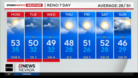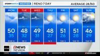
Some much anticipated snow is in the forecast this week as an upper level low slips southeast towards California. There will be enough snow and wind to reduce visibility and slow down travel. Roads will be slick along our mountain passes beginning Monday night and going through Wednesday. A Winter Weather Advisory is up for the Tahoe Basin during those times as well. The worst of the storm will be late Tuesday into Wednesday when the snow becomes steady.

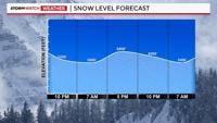
This is a fairly cold storm, especially at night, when the snow level will drop to 5,000’. This means places like Galena, the North Valleys, Virginia City, and Arrowcreek could see some snow both Tuesday and Wednesday morning. Any snow that does fall in the Truckee Meadows will melt quickly. During the day, the snow level will rise to lake level. Virginia City has a 90% chance of seeing a dusting of snow, and a 70% chance of picking up an inch, but only a 20% chance of seeing there.

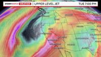
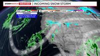
The jet stream will play a big role helping the air to rise and produce snow. The jet stream will be pointed towards the Tahoe Basin beginning Tuesday afternoon, coming out of the southwest underneath the low itself. As the low moves southeast, the jet will move southeast along with it, therefore, diminishing snow chances by Wednesday evening. The jet will favor the Southern Sierra over Tahoe, but a decent amount of snow will still fall around Tahoe as well.

Moisture levels are good, since the low is coming out of the Pacific. We'd have even more moisture to work with if this was a strong atmospheric river, but it's not. From a scale between one to five, I would give this storm a 3. It’s not massive, but it’s not weak either.

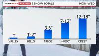
Snow totals will range from no more than a trace in Reno, to a couple inches at or above 5,000’, 3-6 inches at lake level, and 12-18 inches at the crest. Donner has a 90% chance of seeing three inches of snow, a 70% chance of seeing eight inches, and a 40% chance of seeing a foot. At the least, Mt. Rose Summit will pick up 3", but on the high end 13". The expected forecast for Mt. Rose Summit is 10 inches.
The snow will be good for snow making initially, with some water content, before becoming fluffier and less dense by Wednesday.

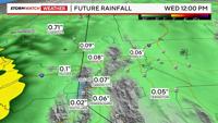
There will be some shadowing in the Truckee Meadows, but there will be some spillover as well. Since the jet will be coming out of the southwest, we should be able to get something. If the jet was coming straight out of the south, it would be a tough go for Reno to get anything. Rain totals will range from .10-.35 inches in the valley. Higher amounts south of I-80, where the jet stream will be closer. Most spots will get closer to a couple tenths.

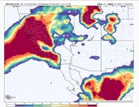
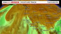
This map shows the odds of at least .10" of precipitation falling throughout the area. This takes into consideration the many members of the GFS model, not just the deterministic model itself, but each of the ensembles. Keep in mind, the Baron model is showing less rain than the GFS or Euro.
Majority of the rain in Reno will fall late Tuesday. Localized areas could see pockets closer to a half inch.
Click on the NevadaWX 2Go page for more blogs and videos.