The calendar now says September but it feels more so like October with highs in the 70’s. No ridge is in sight, which means the hot weather is nowhere to be found in Northern Nevada. All the hot air is further east in parts of the Plains, Midwest, and East Coast.
The jet stream works like a jump rope, with ridges and troughs. While there is a trough over the west coast, there is a ridge to the east. Temperatures are about fifteen degrees below average for this time of year with highs in the 70’s. Overnight lows will be in the 40’s Thursday morning, and slightly warmer Friday morning.

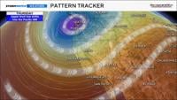
There is a big dip in the jet stream, with individual lows inside the trough. The trough sticks around for a while, with these lows rotating through. The trough will keep us cool with periods of clouds and wind. The trough deepens on Thursday extending rain chances further south to include northern California and Washoe County. Reno could see a few sprinkles on Friday, but chances are low.
We usually look at records for hot weather, but there are also records for record cold. No records are expected to be broken with this stretch of fall weather. We’d have to be in the 60’s in order to do that. However, we are roughly fifteen degrees below average. September can still be a hot month for us.

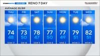
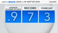
Between September 1st and September 10th, Reno average nearly one day at or below 75 degrees. The record is seven. After Wednesday, we have a couple more chances for that to happen. Highs will be in the upper 70’s over the weekend.
The average high in Reno goes down to 78 degrees by September 30th and 76 degrees by October 3rd. By Halloween, the average high is 64 degrees. Fall is a transition season, where temperatures usually bounce around with both cold and hot days.