
Here comes fall with temperatures dropping fifteen degrees from Monday later this week. A strong cold front will roll through the region on Tuesday, which will also increase fire danger to critical levels. Wind gusts will reach 40 mph and wind prone areas could see wind gusts closer to 50 mph. It will already be windy in the Sierra Monday night with gusts around 50 mph, reaching 70 mph Tuesday afternoon. A Red Flag Warning is up for Washoe, Douglas, Lyon, Storey, and Lassen Counties from 11 am Tuesday through 11 pm that night.

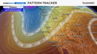
A cold front will move through along with a trough dropping temperatures by quite a bit. Wind speeds are related to pressure which is also related to temperature. The bigger the difference, the stronger wind gusts will typically be. Our terrain and differences in elevation plays a role as well. Wind speeds will be stronger in the afternoon and evening.

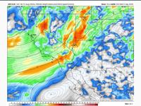
700mb is a good place to look for gusty winds, and models are showing strong winds on Tuesday, as the low gets closer and a front moves through. The stronger winds are shown in the image above in orange.
It will be troughy throughout the week, with individual lows dropping south inside the main trough throughout the week. It will be breezy or windy at times through Friday, but moisture levels will gradually rise throughout the week, lowering fire danger. Wind gusts on Tuesday will reach 40 mph, but they will be very similar on Wednesday. The only difference is that it will be cooler with higher relative humidity values. Temperatures will be in the mid 70’s on Wednesday with lows in the 50’s. It will be hoodie weather in the morning.


Besides the wind it will be great hiking weather this week. It will be too cold for swimming or summer clothes, but a shirt and pants will be perfect. Highs this week will be roughly fifteen degrees below average in Reno.
Our fuels are also extremely dry despite the recent rain on Friday. The ERC (Energy Release Component), is forecasted to slowly go down this week as more moisture moves in, but overall, our fuels are extremely dry. Make sure to stay fire aware. Most fires are human caused. Wind gusts will still be in the 30’s on Wednesday, but relative humidity values will be higher.