After a taste of fall, warmer air will be moving in this weekend. Highs will be in the 80's with a good amount of sunshine. Lows will be getting warmer as well. Reno usually sees its first 75 degree temperature or cooler, on September 5th. Fall is a transitional season, which means we can see big swings in temperatures during the months of September, October, and November. Meteorological Fall begins September 1st. It's not unheard of for light snow to fall in the Sierra this time of year either. The average high in Reno this time of year is around 86 degrees. We've had our fair share of hot days in September too. Ideally, this is the time of year where you can save on both your heat and ac bill.

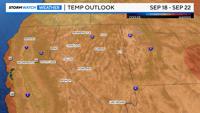
Lately, we've had a huge area of low pressure overhead, providing us with cooler air, with chances of showers. The low continues to move to the east over the weekend, clearing us out and allowing temperatures to warm. Earlier in the week, models were showing a chance for rain early next week, but those have since been removed. The extended forecast is leaning warmer than average between September 18th and the 22nd. The low has been with us for about four days now. The larger the low is, the tougher it is to get ride of.

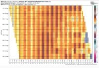
The models did bounce around with next weeks forecast, but have since come together for a warmer and drier forecast next week. The image above shows the different model runs for a particular model. In the Tuesday column you can see how the forecast changed from mid 70's to the 80's within two days. To read the chart look for the day on the bottom of the chart, then look from top to bottom to see how the forecast changes. If it stays consistent that's a good sign. The water year ends September 30th, and we still have a deficit of 0.77" inches. Less than a tenth of an inch of rain has fallen at the Reno Airport this month. Fingers crossed we can get some more by the end of the water year.