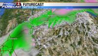
A winter storm warning is up for the Sierra and Lake Tahoe through Saturday evening with 1-2+ feet of snow, and chain controls and travel delays can be expected along our mountain passes.
Look for gusty winds 30-40mph Friday and Saturday as a strong cold front and low pressure system moves through the region. Our valleys will see a few scattered showers and wind today with the best chance for rain on Saturday. It will be much colder with highs only in the 40s by Sunday.
The final push of moisture moves in Sunday night into Monday morning with another round of showers and maybe snow down to the valley floor for the Monday morning commute.
Dress warmly Friday and this weekend and carry chains and expect delays if you are traveling in the Sierra this weekend.
You can stay up to date on weather across the country and in our area with our KTVN Storm Watch weather app.
The app gives you forecast information, like radar, storm tracking and more for any location in the country, all in the palm of your hand.
You can download it for free for your iPhone, iPad, or Android smartphone. Just search KTVN in the iTunes or Google Play Store.
Meanwhile, national park officials have already closed a mountain pass that runs through Yosemite National Park in anticipation of trouble.
The National Park Service says Tioga Road, the soaring eastern entry to the park, closed Thursday night and should stay that way through the weekend.
Officials will also close Glacier Point Road, which offers sweeping views of Yosemite Valley.
They say both roads will be closed through Monday, when the storms are expected to dissipate and road conditions can be assessed
Check http://www.nvroads.com for the latest Sierra road conditions.
(The Associated Press contributed to this report.)