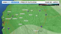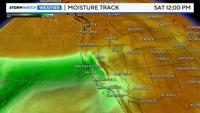
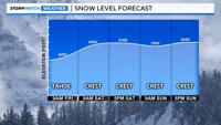
Bring rain gear if you plan on doing anything outside this weekend, as an atmospheric river moves through the region. An atmospheric river is a narrow band of moisture that moves in from the Pacific. They typically bring warmer temperatures and a lot of wind along with them. The snow level will be high with this event, especially over the weekend. It will start out around 6000-6500’ feet Friday morning in northern California before rising to around 8000’ over the weekend. This means that there will be more rain than snow at lake level Saturday and Sunday. The valley will only see rain, and the crest has the best chance for seeing snow. I-80 at Donner will be slick from snow on Friday, before turning to rain for much of the weekend.

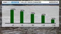
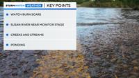
Rain totals will range from at least a couple inches at lake level to at least a half inch in the valley. This will be a long lasting storm, with multiple rounds of heavy rain, carrying into early next week. As of Thursday morning, the main concern will be ponding on roadways, creeks and streams, and burn scars. The Susan River is forecast to near monitor stage by Monday, which is below minor flood stage. The Truckee in Reno is expected to stay below monitor stage. The Feather River is forecasted to near monitor or even minor flood stage by Monday as well.
Now is the time to clear out any plugged drains or gutters. If the snow level is a little higher than expected, reaching 9,000’ then rain totals would be much higher in the Sierra, and the hydrological forecast would be affected too. A snow level change of one to two thousand feet will make a big difference in the forecast.

The track of the atmospheric river is crucial in this weekend’s forecast. A slight wobble to the north by 200 miles would mean more wind than rain in the valley, but a track along I-80 would mean soaking rain and less wind. The models are trending further south along I-80 with each run.
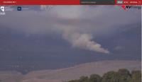
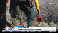
Burn scars, including over the Davis burn scar, will be something to watch for debris flows this weekend. Rainfall rates won’t be as intense as thunderstorms, but the rain will be heavy and steady.

Wind is another thing to watch this weekend, especially on Sunday. It will be windy throughout this weekend, but Sunday will have the highest impacts. Wind gusts will exceed 35mph in the Truckee Meadows on Friday, and over 50mph in wind prone areas on Sunday. Gusts along our ridgetops will exceed 100mph this weekend.
A wobble of the atmospheric river by 200 miles north would mean more wind and less rain.
Stay tuned for more updates.