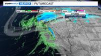
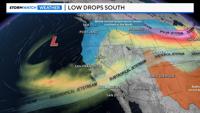
Our snowpack is growing with more snow in the forecast for Thursday and Friday. This will be a colder storm with a good amount of moisture to work with. The atmospheric river is gone, but we have another storm to watch this week. As the cold upper-level low digs south, snow levels will drop, and roads will get messy in the Sierra.

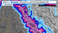
A Winter Storm Watch is posted for the Sierra as a result. It begins in the Tahoe Basin Thursday morning and goes through Friday morning, where 1-3 feet of additional snow could fall. Driving impacts are high Thursday morning through Friday morning. Click below to watch an in-depth video forecast. The blog continues after the video.
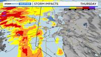
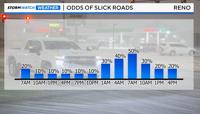
Some light snow could fall early Thursday morning in the valley, causing some problems for the morning commute, but the chance is low. Friday has a better chance of being slick in the lower elevations. Even then, the odds of a slick commute are not 100%. This is a complicated forecast for Reno, with more rain than snow falling in the Truckee Meadows. Towards the end of the storm, at around sunrise, temperatures will be in the 30s, allowing for both snow and ice to form. The line between rain and snow on Thursday morning is a difference of only a few hours.

Snow totals will be less than an inch below 5000’ and less than a few inches below 5500’. Sparks and Fernley have a lower chance of seeing snow than West Reno. Winds will also pick up Thursday night into Friday morning, which can impact the forecast.

Strong winds typically warm temperatures and dry us out. This is what happened over the weekend. As the atmospheric river traveled a little further north than forecasted, it left us with more wind than rain. The wind helped to dry us out as well. I’m confident that moisture will be overhead this time; it’s the temperature forecast that is more challenging.

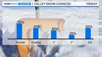
While the wind will help to increase temperatures and evaporate any remaining puddles, the cold air coming in from the north could also drop temperatures enough to have snow. At the same time, warm sub tropical moisture will be moving in. As the less dense warm air goes over the cold air, temperatures will have a hard time rising if it continues to precipitate. With that being said, if wind speeds are strong enough, temperatures could still be in the 40s Friday morning. So it’s a battle between the wind and the colder air mass moving in. Most of the moisture will be gone by the time the snow level reaches the valley floor Friday morning, so any snow that does fall will be light. Frozen puddles will also be an issue. Don't forget Thursday morning either. There's a 20% chance of slick roads in the valley then as well.

Wind speeds could top 50 mph Thursday night, increasing the chance for more power outages, flight cancellations, and downed tree branches. Rain totals will range between .25 and .75 inches. Stay tuned for more weather updates.