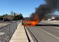
A Fire Weather Watch is posted for western Nevada, including the Truckee Meadows, as well as northeast California for late Saturday morning through Saturday evening. Fire danger will be critical, with low relative humidity values and gusty winds near 40mph. After the hot summer we've had, our fuels are very dry. Gusty winds can make fires spread rapidly. We should always be fire aware in Northern Nevada, but especially on Red Flag Days. A Watch means the ingredients are there and professionals are watching. A warning means it is happening.

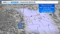
Our winds usually pick up each afternoon and evening during the summer season, because of pressure and temperature differences in the area. This is called the Washoe Zephyr.


The Washoe Zephyr occurs in the Truckee Meadows and Great Basin. The National Weather Service says when the temperature in Truckee is 70° and 90° in Lovelock, there is a 90 percent chance of wind gusts of at least 30 miles per hour.
On hot days, the ground gets hot enough east of the Sierra to allow the air to rise and a surface low to develop. The rising air then gets displaced higher up in the atmosphere, is pushed to the east, and then down towards the surface. This creates a surface high in Truckee. Pressure flows from high to low, leading to a west wind from the Sierra to the valley. This is called the Washoe Zephyr.

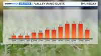
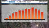
The Washoe Zephyr still occurs when a low moves through during the summer season, oftentimes increasing wind speeds. A large trough will move through the west coast this weekend, leading to 20mph wind gusts by late morning, and near 40mph in the afternoon when the Washoe Zephyr occurs. A Red Flag Warning is issued when winds are stronger and longer lasting than a typical Washoe Zephyr. We should always be fire aware.