Northern Nevada is not known for tropical weather or tornadoes, but we do get a lot of wind. Straight line winds can do as much damage as a tornado depending on the strength of the storm. Both can bring down trees and powerlines, causing considerable damage. A big danger with tornadoes is flying debris. Strong winds can also blow windows out and shatter glass. Of course, strong winds also increases fire danger and travel impacts.

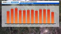
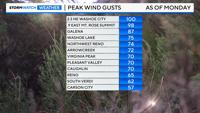
Our recent storm caused some damage in the Reno area as well as power outages. Wind gusts topped 50mph in many locations, with sustained winds topping 30mph in wind prone areas. The Washoe Valley area and northwest Reno reporting wind gusts near 70mph. Wind speeds started to pick up on Saturday, increasing throughout the weekend. By Sunday night into Monday, the front was getting closer and wind gusts were topping 50mph in many locations. Wind gusts topped 50mph on an hourly basis in Washoe Valley along I-580 from 2am Monday through at least 1pm Monday.

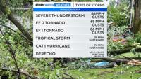
Severe Thunderstorm Warnings are issued when wind gusts are at least 58mph, which means damage is possible. A Tropical Storm requires maximum sustained winds of at least 39mph and a hurricane requires maximum sustained winds of at least 74mph. Which means some spots of Northern Nevada saw low end tropical storm force winds with our latest storm. Keep in mind hurricanes usually last longer than our wind events, but this last one lasted for a decent amount of time. Strong winds persisting for days can do a lot of damage.

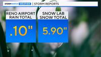
Going forward, wind speeds will be fairly light on Thursday and Friday, before picking up again on Saturday. Wind gusts over the upcoming weekend could top 35mph. There is also a 40% chance for rain in the valley and some snow above 8000'. Reno picked up a tenth of an inch of rain at the airport with our latest storm. The Central Sierra Snow Lab, located near Donner got almost six inches of snow by Tuesday morning at 9:45am.