
Snow showers come to an end by Wednesday afternoon with another storm on the heels of this one.
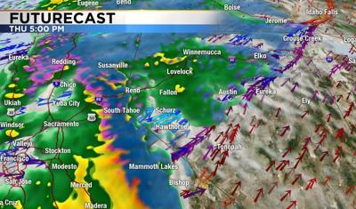
Our Futurecast for Thursday evening shows a warmer storm on the way that will give us rain showers down here and snow above 8,000' in the mountains.
Plan on chain controls and possible road closures along our mountain passes Thursday night through Sunday morning.
A few snow showers are possible early Saturday morning, switching back to rain that will last until Sunday morning.
Watch out for flooding of creeks and streams and clear out your storm drains with a flood watch up for the region Thursday afternoon until Sunday morning.
Snow on roof tops should be cleared if you can to relieve the extra weight from the rain and snow.