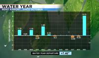
After a long winter and spring, July turned out to be a hot month with only a trace of precipitation falling at the Reno Airport. Records were broken throughout the region as our huge snowpack continues to melt. As of July 30th, 2023 is the third hottest on record in the Reno area for average high temperature, and the 4th hottest on record for the average low temperature. When you look at the high and low combined, it is the third hottest July on record in the Reno area. The drought monitor updates every Thursday and Northern Nevada as well as the Sierra is still below drought status, not even abnormally dry. The water year goes from October 1st through the end of September, and Reno is nearly 7.5” inches ahead of the game. Reno usually sees 7.35” throughout the entire year, we’ve almost doubled that already. With records going all the way back to 1893, Reno has stayed dry for the entire month of July only 9 times, got a trace twenty four times, and received one hundredth of an inch four times. The most rain on record during the month of July is thirty one hundredths.

Not only did Reno break the daily record at the airport on the 16th, but we also tied the all time record of 108 degrees. This happened two other times in Reno, once in 2002 and the other in 2007. This time makes three. The average high for this time of year is in the mid 90’s, so a high of 97 or 98 could still be considered seasonable. A heat wave is defined as usually more than two days with uncomfortable heat and temperatures above average. Looking at the thirty year average, Reno reaches the century mark four times each July, but this year it’s happened eight already. At least half of July was warmer than average in Reno. South Lake Tahoe tied the daily record of 91 degrees on July 23rd, and broke the old record of 89 degrees on July 16th, reaching 93 degrees that afternoon.


Our weather pattern is changing as an area of high pressure sets up over the Four corners, and in a way that allows for more moisture to move into the Truckee Meadows. The flow around the high will come out of the south mid-week, bringing in more moisture and humidity. The storms will not produce a lot of rain initially, leading to dry lightning, but as the storms progress they will be able to produce some rain with time. The storms will be slow movers, allowing the storms to eventually saturate. The trick is getting the lightning lined up exactly with the rain cores themselves.


Flash flooding won’t be a widespread concern, but localized areas of heavy rain is possible. Gusty winds and small hail is also possible. On the plus side, the added cloud cover and storm chances will cool temperatures into the lower 90’s. Make sure to stay tuned to 2News for more weather information.