Fire danger will be critical and lake waters will be choppy over the weekend because of gusty winds. A strong area of low pressure will dip south into the Pacific Northwest on Saturday, increasing the pressure gradient in northern Nevada. The tighter the pressure gradient, the stronger the wind speed will be. Peak wind gusts could reach 40 mph across northeast California and western Nevada, combining with relative humidity values below 16% to produce critical fire danger. A Red Flag Warning is posted for western Nevada and northeast California as a result from 11 am Saturday through 11 pm Saturday.

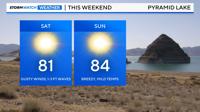
There is also a Lake Wind Advisory for Tahoe, the Truckee Meadows, western Nevada Basin and Range, and Mono County from 11 am Saturday through 8 pm Saturday. The advisory includes both Lake Tahoe and Pyramid, as wave heights could reach three feet. Small craft boating, kayaks, and paddle boarding is not advised, since they can tip over easily.

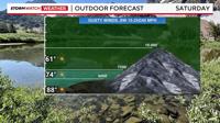
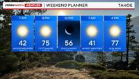
Temperatures will be seasonable this weekend, ranging from the upper 80's in Reno to the mid 70's at Lake Tahoe, and lower 60's above 7000'. Overnight lows will be chilly, dropping into the 50's in Reno and 30's in Truckee. Lows in South Tahoe will be in the upper 30's and low 40's depending on elevation.

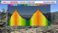
Hiking trails in the Galena area off of Mt. Rose Highway will be slightly warmer than Lake Tahoe this weekend, with highs in the mid to upper 70's, getting cooler as you climb in elevation. Areas above 7000' will see temperatures in the lower 60's. Wind gusts will be in the 30's near 40 mph at times. Winds will be lighter in the morning, gusting in the 20's by 12 pm.