


Heavy rain showers are on the way Friday evening through Saturday with 1 to 3" of rain around our Reno valleys and foothills and 6 to 9" of rain in the mountains below 9,000'.
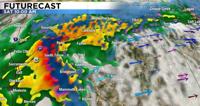
Our Futurecast for Saturday morning is showing heavy rain around the region. The green areas on the map indicate light rain, orange moderate rain, red and purple heavy rain.
Above 9,000’ 2 to 4 feet of snow is possible, always be ready for chain controls in the mountains, but this storm will bring us mostly rain.
For any maintenance and operations concerns related to backed-up water or flooding near Reno, call 775-352-4249.
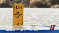
Rivers and streams will be rising with flooding of low lying areas possible, especially along the Carson River in Gardnerville and Markleeville.
A cold front moves in Saturday evening with snow showers possible and slick valley roads for your New Year's Eve plans. Plan on temperatures in the 30s by 11pm on Saturday with a rain/snow mix possible.
Clearing out by Sunday afternoon with chilly 30s for highs. A stormy weather pattern returns for next week as well.
Check out my weather Facebook page here with storm updates all weekend long: https://www.facebook.com/RenoTahoeWeather