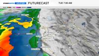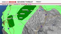
Severe weather is possible in Northern Nevada and California on Friday. This means any storms that do develop could produce hail at least an inch in diameter and or wind gusts of at least 58mph. Severe thunderstorms can down trees and do damage to structures and people if you are not careful. The severe threat lowers after sunset.

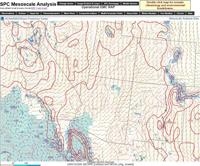
The National Weather Service in Reno just issued a Severe Thunderstorm Warning for western Churchill, Storey, southern Washoe, and north central Lyon county through 1:30pm for quarter sized hail and wind gusts up to 60 mph. The storm is radar indicated and is moving north northeast. It’s also producing a lot of lightning.

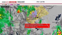
Area in pink could be hail detected by radar. The weather service just added a secondary warning for this storm as it moves northeast. Still capable of producing quarter sized hail and wind gusts up to 60mph. Second warning goes through 2pm.
Severe weather in Northern Nevada is typically much tamer than say Oklahoma or Texas, however, we can get our fair share of active weather too. Flash flooding and fire starts are more common than tornadoes or softball sized hail in the Truckee Meadows. Gusty outflow winds from thunderstorms can also make a fire spread rapidly.

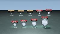
North Central Nevada and California have the best chance of seeing severe weather on Friday. Gusty winds, fire starts, and hail are the biggest threats with any storm that does develop. CAPE stands for convective available potential energy and is food for the storm. Surface cape values are currently ranging from roughly 500-1500 j/kg, which is pretty high for our area.
For other parts of the country 1000 j/kg would be a fairly typical day for severe weather that doesn’t include big tornadoes or huge hail or strong winds. This is enough cape to get some severe thunderstorm warnings issued, but nothing like what they can see in places like Oklahoma on a bad day. Cape values tend to be higher where the sun’s been shining.

Shear is another parameter meteorologists look at during severe weather. High shear numbers indicate variation with wind speed or direction with height. Shear allows a storm to stay upright, and tiled, making it last longer than if it was straight up and down. Shear also gives meteorologists a glimpse at the potential for rotation within a storm.

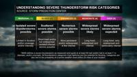
The Storm Prediction Center gives much of central Nevada a marginal risk of severe weather. This means that an isolated thunderstorm could turn severe. The severe storm will be short lived and limited in coverage and or intensity. The risk level is calculated within a 25 mile radius of your location. A marginal risk is the lowest on the scale, after just a risk of thunderstorms, but nothing severe.
There is enough moisture for heavy downpours on Friday, but since the storms are moving quickly, the flash flooding threat is not high, but it’s not zero. Fast storms can be a bigger fire risk.