Travel will be delayed on Wednesday due to Sierra snow and damaging winds. Visibility due to blowing snow will be a problem as well. Thanks to a higher sun angle this time of year, mountain roads will be mainly wet during the day, but if an intense snow band sets up it could stick to the pavement. The odds of having slick roads goes up at night. The majority of the snow will accumulate on grassy areas.


Wednesday through Thursday.
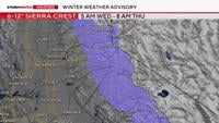
A Winter Weather Advisory is up for the Tahoe Basin through 8 am Thursday due to moderate snowfall and gusty winds. While roads will be wet for the majority of the storm, visibility will be a bigger issue. However, the snow could still pile up during the day during a heavy burst of snow, and at night as temperatures fall. Some parts of the Sierra in the Tahoe Basin, like Palisades-Tahoe are already reporting a foot of snow from Tuesday’s storm.

Overall, the Wednesday evening and Thursday morning commute will be dry in the valley, but windy. Some light rain is possible in the foothills, and even a very light amount of snow can’t be ruled out late Wednesday night, but odds are less than 30%.

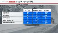
An additional 6-12 inches of snow will fall in the Tahoe Basin near the crest, by Thursday afternoon. This range also includes Donner, where more than several inches of snow will fall by Thursday afternoon. Majority of the snow will fall during the day on Wednesday, mainly collecting on grassy areas.
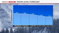
As the snow level drops Wednesday night, dry air will also start to move in, making the showers lighter. Between one to three inches of slushy snow will fall at lake level, primarily after dark on Wednesday. Due to shadowing, the west side of Tahoe will get much more than the eastern side. This is why Donner will get more snow than Mt. Rose.


Lows will fall below freezing area wide Friday morning, with frost possible Thursday morning as well. Now is the time to cover up any sensitive plants due to the cold and wind.