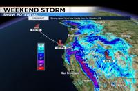
Travel will be nearly impossible over the weekend as a strong storm moves through the region.
Heavy snow will fall in the Sierra with periods of whiteout conditions, making driving dangerous. A plume of sub-tropical moisture will move up from the Pacific, playing a big role in producing high snow totals. The snow will be rich in moisture and water content. This is great news for our water supply.
This kind of snow is typically called Sierra Cement because it lacks the fluffiness of colder/drier snow. While the snow won't be as steady on Sunday, it will still be messy along our mountain passes with scattered snow showers and high snowfall rates. Two to three inches of snow could fall per hour on Saturday, lowering visibility.
The valley will mainly see rain and wind, with a few inches of snow possible late Saturday night into Sunday morning. Temperatures and snow levels will bounce around with this storm, making precipitation type forecasts tricky in the lower elevations.
If it rains hard enough, the weather can switch to snow because of evaporative cooling.

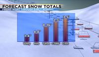
Snow totals will range from 3 to 5 feet in the high Sierra above 8000’, to 2-3 feet at pass level, 8-16 inches at lake level, several inches in the hills, and 1-4 inches at the lowest elevations.
Washoe Valley, Virginia City, and the North Valleys could see a few extra inches of snow compared to the Reno Airport. The valley will also see a good amount of rain on Saturday. Up to a half inch of rain could fall between Saturday morning and night.

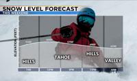
Warm air will be pulled up from the south on Saturday. In fact, temperatures on Saturday will near 50 degrees in the valley. The snow level will bounce around 6000 feet on Saturday, making the snow total forecast in Tahoe tricky. Warm air advection allows the air to rise, and that will be the weather pattern on Saturday. Warm air advection is simply warmer air moving into colder air. This is an atmospheric river event, which is a plume of moisture coming up from the Hawaiian Islands.
This means the moisture is coming from a warmer location and warmer air holds more water. An atmospheric river can also produce a lot of wind along the jet stream. This plume of moisture with the jet will be aimed at I-80 by mid-morning on Saturday.
This will allow for heavy snowfall in the Sierra and rain in the valley. Winds will be strong too. Gusting in the 40s in the valley and over 60mph in the high Sierra. Visibility will be very low as a result. As the atmospheric river moves south throughout the day, the heaviest snow will too.

Snow will start to fall in the Sierra Friday night intensifying into the morning hours. Temperatures will warm in the valley Friday night, allowing for just rain Saturday morning.
Enough cold air will move in Saturday night to drop the snow level to 4500 feet. It will be cold enough for snow in the hills by 11 p.m., and in the lowest elevations by 3am. Highs on Sunday will be in the upper 30s, allowing the snow to melt off the road by noon. Any leftover puddles will freeze Sunday night making the Monday morning commute slick.
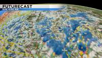
The snow will be scattered and come in waves on Sunday, but could still be heavy at times.
There will be a few breaks in between showers on Sunday, but they won’t last for long. The Winter Storm Warning for the Sierra goes through Monday morning at 4 a.m., and the Winter Weather Advisory for the Truckee Meadows goes from 10 p.m. Saturday through 10 a.m. Sunday.
There is a lot of confidence with this storm, as the models have been in agreement for the past several days. Stay safe and stay warm.