Featured
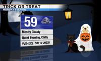
There are no weather tricks in the forecast this Halloween!
There are no weather tricks in the forecast this Halloween!
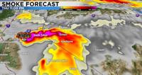
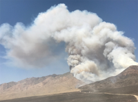
Smoke and haze from the fire will filter into our valleys on and off through the weekend.
Additional Flex Alerts are also possible through the Labor Day weekend as record-setting temperatures are forecast across much of the West.
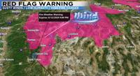
Not expecting much in the way of moisture over the next several days but the wind machine will be cranked on high Sunday afternoon and full bl…

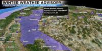
The storm moves out of here by Sunday with cold 30s and 40s for high temperatures this weekend.

Afternoon winds will gust in the 20 to 40 mph range along with low humidity and very dry vegetation.
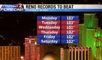
High temperatures will be in the triple digits for the Reno area from about Monday through Thursday. A Heat Advisory is in place for the Truckee Meadows and central Nevada Tuesday through Thursday.

The Bureau of Land Management says the Limerick Fire burning 15 miles northeast of Lovelock is 14,598 acres large at 100% containment.
Sorry folks but more snow is in the forecast Saturday night into Sunday. The majority of the snow will come late Saturday night while you are in bed, with some scattered snow showers popping up Sunday afternoon as well. The mountains will receive the brunt of this cold storm with 1-3 feet possible above 7000’. We’re already seeing some light rain and snow in Reno this evening, but it will switch to all snow by midnight. The atmosphere is made up of different layers...

Areas of smoke and haze are likely around the region due to the Lowell Fire burning near Dutch Flat, CA and the Willow Fire in the Sierra National Forest. Dense smoke is expected around the Sierra crest at times, with haze in the valley and across Northern Nevada due to shifting winds.
Get up-to-the-minute news sent straight to your device.