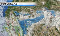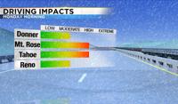
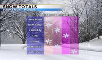
The Monday morning commute will be slick with snow likely. Not expecting an epic amount of snow down to the valley floor but 1-3” are possible. Slightly higher amounts are possible farther south. Usually Donner and the Northern Sierra gets the most snow, but this time around the valley will probably get about the same. The majority of the snow appears to be south of Highway 50 and to the east. This means the central part of the state has a good chance of getting snow as well.

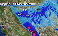
The low will start out near the Gulf of Alaska and move south Sunday morning. As it does so it will get cut off from the jet stream, which can make the storm path very challenging to predict. Normally, a storm travels through the jet stream, but without the jet stream the low has nothing to steer it. The most likely scenario is that the low will move onshore around 10pm rotating bands of snow around it. The center of the low will stay south of I80 giving South Tahoe and the Southern Sierra the best chance for heavy snow. Central Nevada could also see a few inches in the lower elevations, and several inches in the mountains. There is a Winter Weather Advisory posted for White Pine County, Southern Lander County, southern Eureka County, Northwestern Nye County, and Northeastern Nye County. The advisory goes from midnight Sunday through midnight Monday. Snow totals will vary greatly, as the different bands could vary in intensity as they slide up from the south. As a meteorologist I look at a variety of different models. Each model makes thousands upon thousands of calculations, coming up with their own forecast. Both the GFS and Nam shows the heaviest snow staying south of I80.

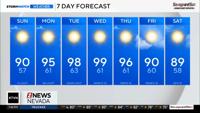
This will be a colder storm with temperatures staying in the upper 30’s Monday. Lows will be in the teens Tuesday morning. As the low moves south there is still a chance for some spotty snow showers through the afternoon. We’ll also have to watch for frozen puddles and black ice. There may be enough time for some of the snow to melt, but not enough time for everything to evaporate by the Monday evening commute. Thanks to an abundance of cloud cover, wind speeds will stay fairly light with this storm. Another system will move through Thursday.