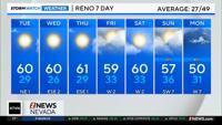

After a warm and dry start to November, we’re now doing better for the water year. It’s amazing how everything can change so quickly. We went from wondering if we would ever get snow to now looking forward to just one dry day. If you’re ready for a break it will be quiet for much of the work week, but it will be foggy Monday morning. The fog won’t stick around for long though. It will be mostly cloudy to partly cloudy for much of Monday with highs in the 40’s.


With plenty of rain and snow on the ground moisture is not lacking. All we need is for the temperature to reach the dewpoint and it will be foggy for the Monday morning commute. As of now it looks quite possible. With clear skies, the temperature will be able to drop rapidly. Clear skies allows all the “heat” we gathered during the day to escape back into the atmosphere. Cloud cover would slow down this process. It will be freezing fog too, so be prepared for black ice.

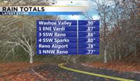
Our yards are quite saturated, especially after all the rain we received this past weekend. The majority of the rain came late Saturday as a front moved through the area. Many spots in town received well over a half inch of rainfall between 5pm and 10pm Saturday. It was even raining hard enough for some ponding on the roadways.

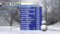
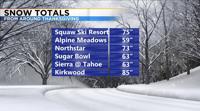
Our ski resorts picked up another 1-3’ of snow this past weekend. Combine that with how much we got around Thanksgiving and many of our resorts now have well over 5 feet of snow. Places like Mt. Rose are nearing 10 feet of snow. A weak system moves through the Sierra late Tuesday, but it won’t be a big deal. Only a couple inches are expected. A stronger storm is expected to move through by late Friday.