It’s been a hot week in Northern Nevada with high temperatures in the 90’s. Which means the little moisture we got this winter is drying out. The National Weather Service just put out their fire outlook for the summer season. The outlook is based on long term weather forecasts, precipitation totals from the past several months, and vegetation assessments. The rest of the blog is based on that.

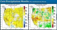
Last year was a below normal summer fire season mainly because of the lack of thunderstorms and wind we saw. This definitely helped our cause. However, we do have some leftover fuels accumulating in the Great Basin from the past few years. While we could use the rain, we never want lightning around here. Hopefully we can get one without the other, but that’s usually pretty difficult in the summer. The Climate Prediction Center gives the west coast a good chance of seeing above normal temperatures through July. It also gives us a slight chance of seeing less than normal precipitation from May through July. It’s a close call though. Reno is right on the cut off between normal and slightly below. So precipitation totals could go either way. If the fire outlook was based only on weather forecasts, it would show a slightly below fire season.


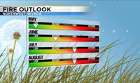
Our lack luster winter and okay spring precipitation, ups the odds of an above normal fire season. We don’t have a lot of moisture to work with. The National Weather Service says the fire threat in June is medium, but it goes up to high in July and August. The NICC (National Interagency Coordination Center), says we’ll probably have a normal fire season in June but an above normal season beginning in July.

We are a couple inches below normal for the water year. Both when you look at from October 1st and January 1st. We are about a quarter of an inch below normal for the month of May as well. We could use the rain. In terms of precipitation, we fell below normal from January through March. Reno was in the bottom 10 percent for 2020. Areas to the east saw nearly record setting low amounts of precipitation through March.

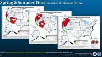
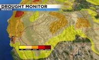
Last year the drought monitor showed no signs of a drought, but the latest drought monitor shows a moderate drought for much of the area. Places to the east are slightly worse. Luckily, we still have some water in storage from the past several winter seasons.

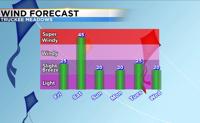
Looking ahead, a low will move through the region Friday through Saturday. Highs on Friday will be in the 90’s, but a low to our south will cool us off significantly this weekend. Highs on Saturday will be in the upper 60’s with gusty winds and rain showers. I can’t rule a few thunderstorms out either.

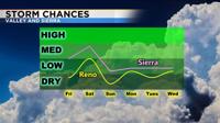
Northeast California will see quite a bit of rain this weekend. Sunday will be dry, with highs in the upper 70’s. Fire danger will be elevated Saturday not only because of storms but also because of wind. Make sure to stay safe and fire aware.