Flooding is a possibility for northwestern California over the next few days because of a strong atmospheric river and area of low pressure moving through. We will have some impacts here in the Truckee Meadows and the Tahoe Basin, but it won’t be as impressive as to the northwest of here.
The rain and snow will come in waves, with some breaks in between. Donner is right at the cutoff for both the snow level and dry versus wet line.
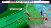
A Winter Storm Warning is posted for the western side of the Sierra through 10pm Wednesday night, where over a foot of snow could fall.
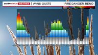
A Red Flag Warning is posted for the Sierra Front including the Truckee Meadows through 7pm Wednesday, unless the Weather Service decides to extend it. Wind gusts on Wednesday will exceed 35mph.

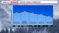
This is a long lasting event, where location of moisture is playing a key role in the forecast. There are a lot of little details that will impact the forecast dramatically. Snow levels will bounce around, but in general it will stay around 7000’ on Wednesday and jump to around 8000’ on Thursday.
Lake Tahoe will see a lot of rain, and areas above 8000’ will see a lot of snow by Monday. The snow level drops to the valley floor briefly Saturday morning and again on Sunday. There will be a lot of shadowing through Thursday, keeping majority of the rain and snow from Donner westward. The west shore of Tahoe will see more rain than the east side. Mt. Rose will pick up more significant snow during the later half of the storm.

Storm impacts are moderate for Donner and the western side of the Sierra on Wednesday, going up on Friday as the snow becomes steady in the Sierra as the atmospheric moves further south. This will be Reno and Carson City’s best chance for spill over as well.
Wind is the biggest threat on Wednesday, increasing fire danger. Strong winds combined with low relative humidity is a recipe for critical fire danger. Relative humidity values will go up somewhat on Thursday, but with some shadowing it will still be something to watch.

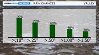
Reno could see anywhere between .25-.75 inches of rain by Saturday morning. There is a 30% chance of more than an inch and half by Saturday afternoon. Northwestern California could see a foot of water content by this weekend and the west shore of Tahoe could see over an inch of rain.

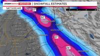
Snow totals will be high with this storm, especially north of I-80 and over Mt. Shasta. Closer to our area, the Sierra will see one to two feet by Thursday night, and an additional couple feet of snow by Saturday. More snow will fall on the west side than the east side. Snow totals also go down south of Tahoe. Snow is possible in Reno Sunday morning, but it’s still too far away to nail down exact amounts. Roads will be slick at all elevations by the later half of the weekend.
Stay tuned for more weather updates.