Now is the time to clean any storm drains from debris and snow to lower the flood risk over the next few days. An atmospheric river is forecasted to move through the region Thursday through Sunday, bringing rain, wind, and high elevation snow throughout the region.
Creeks and streams will be the most vulnerable to flooding with this storm. The good news is our snowpack is expected to absorb the majority of the rain like a sponge.
Areas below 5500’ with less snow on the ground will see more snowmelt than the higher elevations. The deeper, fluffier, the snow, typically the more water the snow can hold. Snow that is heavy in water content and very saturated has a hard time absorbing more water.
You can test this out by pouring water on a dry sponge versus one that is soaked in water. The water takes longer to spill over with the dry sponge, but spills over immediately with the one that is soaked. The size of the sponge makes a difference too. The bigger the volume or space the sponge has, the more water it can hold before everything spills over.
Atmospheric rivers are associated with warmer temperatures and wetter snow. This is what we saw on New Year’s.
The storms lately have been colder, producing fluffy snow that piles up easier, but also has less water content. This can be explained with snow ratios. A colder storm would have a higher snow ratio, while a warmer storm has a lower ratio.
For example, on average a tenth of an inch of liquid equals an inch of snow, but with a higher snow ratio the tenth of an inch of liquid would equal way more snow.
On average, when the temperature is near freezing the ratio is 10:1, but lately the Sierra has been seeing ratios closer to 15:1 because of colder storms. This means we have a good top layer of fluffy snow that is porous and deep. We also have a ton of snow, which means we have a bigger sponge to absorb all of the rain.
As the warmer rain falls on top of the colder snow the water cools, freezes, and goes from a liquid to a solid.
Once that happens, the frozen water is pretty much not going anywhere. It’s like pouring warm water in a giant cold sink.

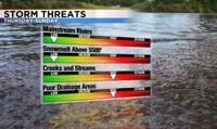
Areas below 5500 feet with less snow on the ground compared to the mountain passes, could see some flooding mainly along creeks and streams, and poor drainage areas. The wind will help to melt the snow in the lower elevations too.
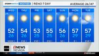
The Truckee River in Reno is forecasted to stay below flood stage this weekend, which is good news.
A Flood Watch has been posted for the Truckee Meadows and Sierra from Thursday afternoon through Sunday morning, mainly for poor drainage areas. Remember, if you see standing water, it’s best to turn around as it is oftentimes deeper than you expect.