See the latest forecast and weather information from the 2 News Nevada Storm Watch Weather Team of meteorologists
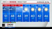
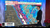
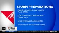
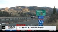
Merry Christmas Eve! We are starting out the day with showers sweeping across the region falling as valley rain and mountain snow. Snow levels this morning are around 8000' but will drop between 6000'-7000' this afternoon. High temperatures in Reno broke records with 63 degrees yesterday telling me that most of the precipitation in Nevada Valleys will fall as rain today. Widespread coverage of showers continues this morning with consistent moisture before isolated showers this afternoon. This afternoon showers will be isolated with potential for heavy precipitation at times but will be faster moving and more brief. Winds this morning have been breezy gusting between 25-35mph but will calm down by the afternoon hours today. Snow levels this morning remain above 8000' with a wintery mix between 7000'-8000'. Expect chain controls on mountain passes so drive safely and smoothly. Snow levels will drop this afternoon between 6000'-7000' and will continue to drop on Christmas and Friday. Winter Weather Warnings are now in effect in the Sierra until 10am on Friday. Lake Level will be seeing chances to get 1-2 feet of snow throughout this forecast period with higher values above 7000 feet.