
Your Latest Forecast

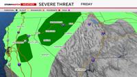
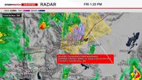
Get ready for a busy weather weekend with thunderstorms, rain, and snow in the forecast. Showers will continue to gain momentum in the morning Friday with light rain favoring the mountains. After 11am, shower potential will reach a 70% chance throughout lower elevations in Nevada with a 90% chance in the mountains. Some of the storms could turn severe, producing hail of at least one inch in diameter and wind gusts over 57mph. Showers slowly calm down Friday night, favoring slight chances overnight going into tomorrow morning before cranking up again in the later afternoon Saturday through Sunday morning. 

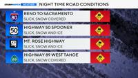
The Winter Storm Watch for the Tahoe Basin has been upgraded to a Winter Storm Warning and begins on Saturday at 2pm, going through Sunday at 11pm. Snow totals will range from 6-10 inches at lake level below 7,000’, to 12-28 inches above 7,000’. Sierra roads will be slick at times, especially at night as temperatures cool. Visibility will be low as well.

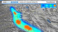
There is a slight chance the valley could pick up a light amount of snow early Sunday, but impacts will be minor to nonexistent. Virginia City could pick up an inch or two, but closer to the airport, no accumulations are expected. Highs on Sunday will be in the upper 40’s with rain showers.

Reno, NV

Right Now
46°
Cloudy
  • Humidity: 68%
  • Feels Like: 40°
  • Heat Index: 46°
  • Wind: 11 mph
  • Wind Chill: 40°
  • UV Index: 0 Low
  • Sunrise: 06:29:29 AM
  • Sunset: 07:32:10 PM
  • Dew Point: 36°
  • Visibility: 10 mi

Today

Rain ending early. Remaining cloudy. Low 41F. Winds W at 10 to 15 mph. Chance of rain 70%.

Tonight

Rain ending early. Remaining cloudy. Low 41F. Winds W at 10 to 15 mph. Chance of rain 70%.

Tomorrow

Cloudy. A stray shower or thunderstorm is possible. High 58F. Winds SSW at 10 to 20 mph.

Day
Temp
Fri
41°
65°
Fri
65°/41°
Periods of rain early. Lows overnight in the low 40s.

Chance of Rain: 73%

Sunrise: 06:29:29 AM

Sunset: 07:32:10 PM

Humidity: 68%

Wind: W @ 10 mph

UV Index: 0 Low

Friday Night

Rain ending early. Remaining cloudy. Low 41F. Winds W at 10 to 15 mph. Chance of rain 70%.

Sat
35°
58°
Sat
58°/35°
Mostly cloudy. Highs in the upper 50s and lows in the mid 30s.

Chance of Rain: 15%

Sunrise: 06:27:58 AM

Sunset: 07:33:10 PM

Humidity: 46%

Wind: SSW @ 16 mph

UV Index: 4 Moderate

Saturday Night

Considerable cloudiness with occasional rain showers. Low near 35F. Winds SW at 10 to 15 mph. Chance of rain 60%.

Sun
31°
49°
Sun
49°/31°
More clouds than sun. Highs in the upper 40s and lows in the low 30s.

Chance of Rain: 19%

Sunrise: 06:26:27 AM

Sunset: 07:34:09 PM

Humidity: 47%

Wind: SW @ 15 mph

UV Index: 5 Moderate

Sunday Night

A few clouds. Low 31F. Winds W at 10 to 15 mph.

Mon
32°
54°
Mon
54°/32°
Mix of sun and clouds. Highs in the mid 50s and lows in the low 30s.

Chance of Rain: 15%

Sunrise: 06:24:57 AM

Sunset: 07:35:09 PM

Humidity: 49%

Wind: NW @ 11 mph

UV Index: 6 High

Monday Night

Mostly clear skies. Low 32F. Winds WNW at 10 to 15 mph.

Tue
36°
62°
Tue
62°/36°
Times of sun and clouds. Highs in the low 60s and lows in the mid 30s.

Chance of Rain: 3%

Sunrise: 06:23:27 AM

Sunset: 07:36:09 PM

Humidity: 41%

Wind: WNW @ 13 mph

UV Index: 7 High

Tuesday Night

Generally fair. Low 36F. Winds W at 10 to 15 mph.

Wed
39°
62°
Wed
62°/39°
Mix of sun and clouds. Highs in the low 60s and lows in the upper 30s.

Chance of Rain: 5%

Sunrise: 06:21:58 AM

Sunset: 07:37:09 PM

Humidity: 38%

Wind: WSW @ 16 mph

UV Index: 6 High

Wednesday Night

Partly cloudy. Low 39F. Winds WNW at 10 to 20 mph.

Thu
30°
57°
Thu
57°/30°
Times of sun and clouds. Highs in the upper 50s and lows in the low 30s.

Chance of Rain: 13%

Sunrise: 06:20:29 AM

Sunset: 07:38:09 PM

Humidity: 38%

Wind: NNW @ 12 mph

UV Index: 7 High

Thursday Night

A mostly clear sky. Low near 30F. Winds NNE at 10 to 15 mph.

Most Popular

Get up-to-the-minute news sent straight to your device.

Topics

Breaking News