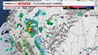
It’s not every day that both snow and thunderstorms are possible at the same time, but that is exactly the case Wednesday afternoon in Northern Nevada and California. We have an area of low pressure located mainly offshore of California, with a couple embedded lows inside it.
One of those embedded lows is located just west of San Francisco. The upper level low is providing the upper atmosphere with cool, unstable air - cold enough for snow in the Sierra, and warm enough for regular thunderstorms to the east. The snow level drops to 5,500' early Wednesday night.

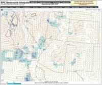
This map shows cape values throughout the area. They are not super high, but are high enough for storms. Mainly in the hundreds.
CAPE values are not super high, but high enough to get some thunderstorms going. Not only is snow possible in the Sierra through Wednesday evening, but thunderstorms are also possible, especially in the Basin and Range through early Wednesday night. Graupel and small hail is possible with any storms that do develop. CAPE values are dependent on the amount of sunshine we receive, with enough breaks in the clouds Wednesday afternoon for storms to get going.
CAPE stands for Convective Available Potential Energy, and measures the amount of fuel the storms have to feed off of. The higher the CAPE value, the more likely storms are to occur and be strong. Lightning is already being detected in the Fallon area as of 1:30pm.
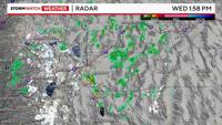
The thunderstorms are quickly moving from south to north and are producing some rain. The trick is to get the rain lined up with lightning perfectly to avoid any fires. The rain cores are not super big, but not tiny either.

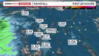
Since this system is convective in nature, it gives the valley a better chance at seeing showers too. Once the sun sets, CAPE values will go down. As of late Wednesday morning, .07” of rain fell at the Reno airport since Tuesday night. Just over a tenth of an inch of rain has fallen in Carson City. Watch out for frozen puddles Thursday morning.