

While some people are enjoying the warm spring like weather, others are anxious to hit the slopes. We finished the 2019/2020 water year at least three inches behind, so we really could use the snow this year. Highs have been running about five to ten degrees above normal for a while now and could go through at least the first half of next week.
"Cold and snowy always. We're a ski shop. Sunny and warm in July and August when we sell furniture,” said Pat Parraguirre, manager of Bobo’s Mogul Mouse Ski and Patio.
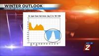
La Niña is helping to keep us dry and mild. It is associated with cooler ocean temperatures along the Eastern Pacific ocean near the equator. Water temperatures started falling this past spring. There is a good chance La Niña will make it through much of the winter season.

"I'm a half full person, so I'm hoping and looking at long term forecasts,” said snow lover John King.
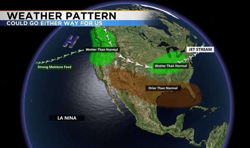
A La Niña setup brings the polar jet down and aims it right at the Pacific Northwest, with drier conditions over southern California. Reno is right in between the two. Meaning it could go either way for us. A weak La Niña could bring the polar jet farther south, and a strong La Niña would keep it farther north. Right now it's looking more moderate.

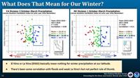
This chart shows the amount of precipitation we've received over the past several winters, and their correlation to La Niña and El Niño. You can tell there is not a huge difference between the two patterns. We have seen just about everything with both a La Niña and El Niño pattern. But on average precipitation totals are slightly lower for La Niña years.

La Niña can also increase our risk of flooding from atmospheric river events. But this is not something to bank on. An atmospheric river draws up moisture from the Hawaiian Islands, and acts like a water hose, spraying moisture along the west coast. This can bring heavy precipitation and strong winds to our area. The warm nature of an atmospheric river can be a flood threat as well.