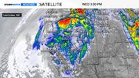
Some storms are fast movers and others can sit there for days, pouring down rain. Our current storm is not super fast, but will get out of here by late Friday. The weather pattern resembles a pinwheel, with an area of low pressure spinning over California and Nevada for approximately 48 hours. As the low sits over us, bands of rain and snow are rotating up and around the low. Moving in a circular, counter clockwise motion. There are some breaks in between the rain bands, and there are also some pockets of heavier rainfall.


The circle represents the low itself, and the red, white, and blue streamers represent the different rain bands rotating around the low.
Click here to see a video explaining how the pinwheel relates to our forecast on YouTube. Make sure to hit subscribe.
In the image above, the pinwheel represents the low, just sitting in place, spinning, with the red, white, and blue bands inside the pinwheel representing the rain bands coming and going. While the center of the low is sitting over the Tahoe Basin, impacts extend all the way out to Idaho, California, and Oregon. As the low moves south and east the position of the rain bands moves with it. By late Friday the rain moves east towards Utah.
The low is cut off from jet stream, making it hard for the low to get out of here. The jet stream steers storms, but when the low is disconnected from the jet stream, it just sits about for a while. Cut off lows can be very tricky to forecast for, because of this.

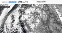
The low is easier to pick out on satellite, with the spin of the low clear to the eye. Embedded within the low are pockets of heavier rainfall. Moisture is also able to come out of the south in advance of the low. The rain bands are coming out of the south from Lyon County up through Humboldt County, then moving east to west in the Truckee Meadows, and then south again towards the Tahoe Basin. This creates a counter clockwise spin around the low.

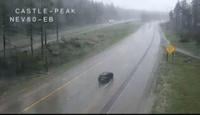
I-80 at Donner is wet as of 3:15pm on Wednesday, and this is what it will look like on Thursday as well. While snow will fall from the sky from time to time, it will melt as it hits the ground during the day. At night, it could accumulate on pavement and make roads slick.
It is cold enough for snow to fall in the High Sierra, but the ground is warm enough for it to melt during the day. Places like Mt. Rose Highway and around Mammoth Mountain could be slick at night as temperatures cool and snow begins to accumulate on the pavement. Donner could be slick late Wednesday night into Thursday as well.

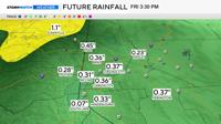
Rain totals will vary with Fallon, Lovelock, and Fernley seeing more rain than West Reno. The Sierra will get more rain than the Basin and Range though. Reno and Carson City will see anywhere between a .10-.25” of rain by late Thursday. Localized areas could see over an inch, depending on if a thunderstorm develops in that area.