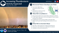
The National Weather Service in Reno says a late-week shift in weather patterns will likely bring an increase in thunderstorms across the region starting Friday and continuing into next week.
A high-pressure system over the Four Corners region, where Arizona, Colorado, New Mexico, and Utah meet, is drawing monsoonal moisture northward, boosting the odds of daily storms. The Four Corners area has a mix of landscapes, from flat desert areas to tall mountains, which leads to a variety of weather patterns, from hot, dry summers to cold, snowy winters. "Thunderstorm chances increase Friday through next week," the agency posted on its X page.
Forecasters say they are confident that an active period of storms will begin Friday and peak over the weekend.
There’s a 15 to 30 percent chance of storms Friday, especially south of U.S. 50, with higher chances spreading north through the weekend.
The weather service warns that dry lightning could start new fires, particularly on Friday.
Wetter storms could also pose a risk of flash flooding through the weekend and into early next week.
NWS officials caution that the exact timing and coverage of storms remains uncertain. "Cloud cover may inhibit storms, especially this weekend," the agency said, adding there is also a possibility of nighttime thunderstorms.
In response to potential flooding, Washoe County is urging residents to prepare now. "We may experience some storms Friday and into next week," the county said in an online post. "If your property is prone to flooding, now is a good time to prepare. Our sandbag locations are stocked and ready for you! Bring a shovel."
More details about sandbag locations and preparedness can be found below.


(The National Weather Service Reno and Washoe County both contributed to this story.)