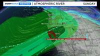
The weekend before Christmas through the week of will be the most active week we’ve seen so far this season. An atmospheric river will move south on Friday, kicking up our winds and giving us a chance for rain. The plume of moisture will lift northwards over the weekend, giving the Sierra a good chance for rain by late Saturday. The Truckee Meadows has a good rain chance as well. There will be plenty of moisture to work with, but cold air will be missing until Christmas Eve.
Key Points:
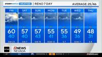
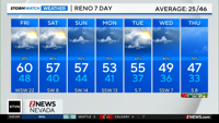
1. Snow levels will be high through this weekend, with heavy rainfall likely in the Sierra
2. Winds will be strong on Friday and Sunday
3. Colder air moves in by Christmas Eve, snow is likely along our mountain passes


Atmospheric rivers are narrow bands of moisture that can develop all the way down in the Hawaiian Islands. They act like a water hose, providing the west coast with lots of water. They can also increase wind speeds.
A Wind Advisory is up for much of Northern Nevada through 4am Saturday, because of wind gusts up to 55mph, and wind prone areas like Washoe Valley could see wind gusts closer to 65mph. Make sure to stay fire aware on Friday. This will be a moderate atmospheric river, with an impressive amount of rain falling in the Sierra between Friday and Tuesday. Winds will pick up in the valley on Sunday as well.

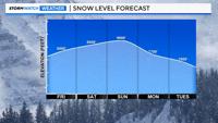
Snow levels will stay high through the weekend, mainly above 8000'. Depending on how hard it rains, the snow level will bounce around, give or take 500-1000'. The snow level reaches 6500' by Wednesday.
Snow levels will be high through the weekend. On Friday, snow levels will hover around 8000’, and they’ll reach 9000’ by Sunday. South Lake Tahoe will pick up several inches of rain by Tuesday. Donner will pick up even more.
A cold front is draped across northwest California, putting the Truckee Meadows and Tahoe Basin in the warm sector for a while. Atmospheric rivers are tropical, with moisture sometimes coming up from the Hawaiian Islands. This is why AR events are typically warm.


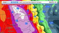
Heavy rain will fall in the Sierra through Tuesday. The snow level will be around 8000' on Friday, 8600' on Saturday, and 9000' on Sunday. This map shows both rain and melted snow amounts, or water content. Lake Tahoe could see several inches of rain by Tuesday.
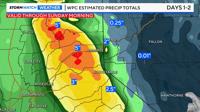
Minor flooding along our creeks, streams, and poor drainage areas are possible this weekend, especially on Sunday in the Tahoe Basin. Rockfalls and mudslides are also possible. Our mainstem rivers will rise, but no flooding is expected at this time. Watch out for ponding on roadways as well. The water is oftentimes deeper than it appears. With hardly any snow in the Sierra, the flood risk is lower than it could be.

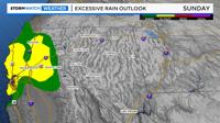
According to the Weather Prediction Center, Northwest California has a slight chance of excessive rainfall on Friday, and the Sierra has a slight risk on Sunday. It’s a marginal risk for much of Northern California on Saturday. A marginal risk means at least a 5% chance of rainfall totals exceeding flash flooding guidance within 25 miles of a point. A slight risk means a 15% chance.
Our Public Works crews are actively monitoring this weekend’s potential storm and working through all their routine pre-storm checks. We will continue to monitor the forecast and adjust as necessary. Thanks, Public Works! pic.twitter.com/8kVehmp6D5
— City of Sparks, NV (@cityofsparks) December 19, 2025