Unlike last year, January is usually Reno’s wettest month of the year. The storm gate is still open and looks to stay that way at least for the next couple of weeks. There will be brief breaks every now and then, but more stormy days than dry days overall. Not only do we have storms lined up, but atmospheric rivers. An atmospheric river is a plume of moisture coming up from the Pacific that rides along the jet stream. Atmospheric rivers are good in that they can really help us get out of a drought, but they can also lead to flooding if the timing is right. Since they come up near the Hawaiian Islands, they are usually associated with warmer temperatures as well. This can lead to melting our snowpack and increasing the flood risk. Warm air can hold more moisture than cold air.
Along with atmospheric rivers, we’ve also had a lot of warm air advection with warm fronts moving through. Northern Nevada does not see very many warm fronts, as they usually break a part before they get here. A warm front is the leading edge of a warmer air mass. Light precipitation is possible along warm fronts. Warm air advection can cause the air to rise as well, and that is what it sounds like. Warmer air moving into colder air. This is what happened Wednesday night into Thursday morning leading to pockets of rain and freezing rain.

If you have any travel plans, Friday would be the time to do so, before another storm moves in over the weekend. A weak area of high pressure builds Friday, keeping the storm track out of our area for the time being. The storm over the weekend will reach its peak Saturday night into Sunday morning. A stronger storm will move through Monday and Tuesday bringing heavy rain and snow along with it. This will be another atmospheric river event with warmer temperatures, increasing the flood risk in the Truckee Meadows.
The GFS model goes out two weeks and the Euro model goes out about ten days, both models keeps the pattern active through at least the middle of January. Forecast confidence goes down with time, but the trend is wet and active for a while. The Climate Prediction Center gives Northern Nevada and California an equal chance of having a cooler or warmer than normal forecast for the end of the month. It is also trending wetter than normal towards the end of January. It is likely January 13th through the 19th will be wetter than normal.

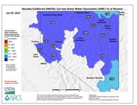
While the snow is tough to drive in, our snowpack is in great shape. The Tahoe Basin is 215% above normal, and the Truckee is 197% of the median. The snow that fell over the weekend in the valley and continues to fall in the Sierra has a lot of water in it. Great for making snowmen.