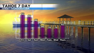

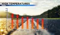
A Heat Advisory is in effect for western Nevada and goes through Saturday night. Not only will it stay hot during the day but there won’t be a ton of relief at night either. Records have the potential to be broken over the next few days as well. In order for it to be considered a heat wave, temperatures have to be abnormally hot for at least two consecutive days, but they generally last for more. According to NOAA they can occur with or without high humidity. A sticky feel to the air can make temperatures feel even hotter. This is a perk about living in a desert, rarely is it muggy around here and oftentimes temperatures cool off pretty quickly at night. High temperatures will be in the triple digits through the first half of the weekend in Reno and low 90’s at Tahoe. Overnight lows will be about ten degrees above normal as well, reaching the upper 60’s and low 70’s. Ninety five is the average high this time of year in Reno and the average low is sixty one. For South Tahoe, the average is eighty two during the day and forty three overnight into the early morning.

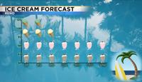
If you don’t have air conditioning you’ll have to find another way to cool off. The ice cream forecast calls for four ice cream treats through Saturday, three on Sunday and two much of next week. If you’re tired of the heat, some cooler air is on the horizon. We just have to get through this heat wave first. We’ve already tied or broken a couple records for overnight lows. The low Wednesday morning in Reno was seventy-three degrees, breaking the old record set back in 2003 by four. We also tied the record in Reno Thursday morning with a low of sixty nine, set back in 1931. According to the National Weather Service, the morning low has been 73 degrees or warmer only fourteen times since records began at KRNO in 1998. This is partly why we have a Heat Advisory in effect. Not only is it hot during the day but it is abnormally warm at night as well.

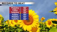
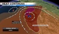
Reno broke the daily record on Thursday, with temperatures in the triple digits. Saturday will be the hottest day of the week with highs reaching a few degrees above 100. By Sunday the ridge starts to break down allowing for some cooler air to move in, along with some moisture. High pressure is centered right over us, keeping storm chances either well north of I80 or from Tahoe southward. Any storms that do develop around Lake Tahoe Friday will be isolated. There is a better chance of thunderstorms for all of us early next week.