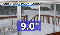
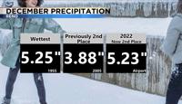
Multiple records were set in Reno this month. Nine inches of snow fell at the Reno Airport on Saturday, December 31st, breaking the daily record for snowfall. The snow was heavy in nature with a lot of water content. Roads will be very icy Monday morning because of frozen puddles. Highs on Monday will be in the mid 30’s with some melting during the middle portion of the day before a much weaker system moves through Monday afternoon and evening. Several more inches of snow will fall in the Sierra and less than an inch in the valley.

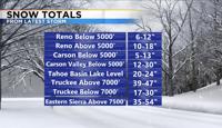

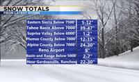
Atmospheric rivers can be tricky to predict but they are known for producing heavy rain, snow, and strong winds. The cold air arrived much quicker than expected all while the atmospheric river, or plume of moisture from the Pacific was still aimed right at us. This allowed for a ton of snow falling in the region. Instead of getting heavy rain we got heavy snow. Snow totals ranged from six to twelve inches below 5000’ to multiple feet of snow in the High Sierra. Snowfall rates were impressive, especially in the mountains. The Sierra Snow Lab located near Soda Springs reported 7.5” of snow between 4 and 5pm alone on Saturday. Snow totals would have been even higher if it was colder. The snow also helped lower the flood risk along our creeks, streams, and main stream rivers. The Truckee in Reno peaked Saturday morning around 11am at 8.87 feet, staying below action stage with a flow of 4460 cfs. It would have been higher if it didn’t start snowing Saturday morning.

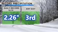
If you were to melt all of the snow and measure it, Reno picked up 2.26 inches of water on the 31st alone, which breaks the record for that day.

This is also third wettest day ever recorded at KRNO in Reno. The storm gate stays open through at least the middle of January. Another strong storm with good atmospheric river signals moves through Wednesday and Thursday, so stay tuned for updates. Follow me on Facebook at KTVN Angela Schilling.