Photo by Carla Brockman
A rare deep area of low pressure is moving through northern Nevada this weekend, dropping temperatures well below average. Reno broke the daily record for cold high temperatures on both August 23rd and 24th.
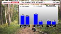
The high on Friday was 69°, beating the old record set back in 1904 by two degrees. Reno smashed the old daily record for August 24th by 17 degrees on Saturday. This not only breaks the daily record but also beats the all time coldest high temperature in August with a high of 57 degrees.
Highs on Sunday will be in the 70’s, which is roughly 15 degrees below average. Lows will be in the 30’s and 40’s in the Truckee Meadows Sunday morning, with a Frost Advisory posted for parts of central and eastern Nevada through Sunday morning.

Rain totals varied quite a bit in the Reno area, with more widespread rain in northeast California. It was cold enough for light snow in the high Sierra as well. Mt. Rose Ski, Palisades, Mammoth, and Donner all reporting light amounts of snow on Saturday.

Several hundredths of an inch of rain fell at the Reno Airport on Saturday. Snow is not unheard of this time of year in the mountains, but it’s not typical.

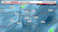
Rainfall estimates according to radar shows a range of several hundredths of an inch of rain in the Reno area to a quarter of an inch of rain in the North Valleys on Saturday. Parts of northeast California possibly picking up closer to a half inch of rain so far this weekend. High pressure builds in this work week allowing temperatures to warm into the 90’s again and drying us out.