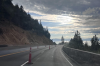
Travel will be impacted this week along our mountain passes, especially in Mono and Alpine counties. Snow is also possible along Mt. Rose Highway and Donner, but amounts will be lighter to the north.
Rain is also possible in the valley this week, with higher totals expected to the south.
Before the rain and snow, comes the wind. It was breezy on Sunday, and Monday will be very similar. Wind gusts will reach the 30’s in the valley on Monday, and top 40mph in the high Sierra.
Snow chances are very low in the central Reno area, and while still low, the chance is slightly higher in the hills. Mainly in the morning.

This will be a slow-moving storm approaching northern California a couple days before Reno sees any rain.
Tahoe will see snow one day before it rains in Reno. There is not a lot of congruence in the forecast between models.
What they are agreeing on is that snow will fall in the mountains this week with rain in the valley.
What they are disagreeing on is the exact track of the low and therefore the amount of precipitation. The low will get cut off from the jet stream, which makes the low harder to track.
As the low moves southeast, it will spin up bands of rain and snow from the south.
The peaks of Mono County have a 50-70 percent chance of seeing over ten inches of snow. The Tahoe Basin has less than a thirty percent chance of seeing over several inches.

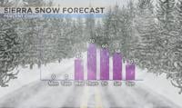
The first band of rain and snow will fall in western California north of I-80 on Tuesday. The second band of snow will hit I-80 including Donner on Wednesday. Reno will start to see rain by early Thursday.
The rain shadow effect will impact how much rain falls in Reno on Tuesday and Wednesday.
A southerly wind in advance of the low at the surface is a good sign that most of the valley will be shadowed out and drier than the mountains. The wind direction in Reno will be out of the south through Wednesday, before turning more southeasterly on Thursday.
It will also be cooler this week with highs in the 50’s.

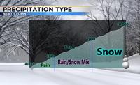
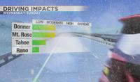
This will not be a huge storm, but strong enough to slow down traffic and make roads slick above 6500’.
The snow level will bounce around during the day, which means Lake Tahoe will see a mix of both rain and snow this week.
Highs in Reno will reach the 50’s by the later half of the week with lows in the mid 30’s.
Places like the North Valleys will more than likely just see rain out of this storm, but we’ll have to watch it closely as the mid 30’s are close to freezing.