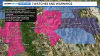
A Red Flag Warning is up for the Sierra Front and areas east including Fallon and Lovelock, through 11 p.m. Sunday night.
Make sure to be extra careful when it comes to fire danger.
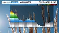
Wind gusts could reach 40mph, which is strong enough to carry a fire rapidly. The relative humidity is low as well, dropping below 15% at times. Humidity levels and wind gusts will vary some throughout western Nevada, but in general the air is very dry, and winds are strong, so make sure to take precautions.
It will still be breezy Sunday night into Monday with relative humidity values gradually increasing to the twenties by sunrise.


Some activities to avoid include mowing, riding four wheelers, campfires, towing and smoking.
Folks should still be careful when the warning expires, but a warning means the danger is higher than normal.
Wind gusts will be slightly lighter Sunday night but still gusting in the 20s at times.

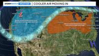
Cooler air moves in behind a front by Monday morning. In fact, it is the transition between warm air and cool air that increases wind speeds.
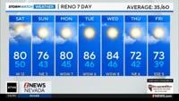
Highs on Monday will range from the 60s at Lake Tahoe to around 70 degrees in the Reno area. Tuesday morning will be chilly, with frost possible in outlying areas above 4500’.
Even Carson City will drop near freezing Tuesday morning, so you might want to bring any sensitive plants indoors Monday night.

The Reno Airport will be in the lower 40s Tuesday morning, but places like Cold Springs will be in the mid to upper 30s. The spring like weather sticks around for a couple days before the heat returns later in the week.