


This winter has had a delayed start so far with warm and dry conditions running well above seasonal averages this week. The main reason it has been dry and warm is from constant influence from Ridge patterns persisting along the Western United States. This ridge is causing the flow of the atmosphere to push in warmer and dryer conditions from the west and southwest. Warm air from the south west helps increase temperatures coupled with the dry air producing sunshine to give us more energy from the sun to further increase temperatures. Unfortunately this pattern is elongated and expected to take over most of the region throughout this week into next week.
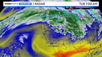
Water Vapor Radar imagery shows that dry air signified by the yellow air mass continues to take over the South West. Most of the moisture used for clouds, showers, and snow has been favoring the Pacific North West due to the atmospheric river being pushed north.
You can see on the moisture track that all of the precipitable water for showers favors rain along the Pacific North West. Since this moisture is being carried by the warm airmass it will fall mostly as rain to the Pacific North West with snow levels being high in the Northern Rockies.
As the high pressure ridge continues to supply warm and dry air this will lead to record breaking potential Tuesday, Wednesday, and Thursday. Luckily after Thursday temperatures start to trend down before the next system arrives mid week next week.
Next week temperatures are expected to drop mid week as we will see cooler air press in from an area of low pressure that will track mostly north of the region and eventually settling into the Northern Rockies. Confidence is still low on if there will be moisture with this system tracking south enough to see Sierra mountain snow.