
From the U.S. Forest Service:
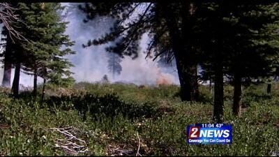
The Tahoe Douglas Fire Protection District (TDFPD) and the U.S. Forest Service Lake Tahoe Basin Management Unit (LTBMU) will conduct prescribed fire operations in numerous locations around the Lake Tahoe Basin beginning tomorrow, Saturday, October 18, 2014.
Fall and winter bring cooler temperatures and precipitation, which favor prescribed burning. Each operation follows a prescribed fire burn plan, which considers temperature, humidity, wind, moisture of the vegetation, and conditions for the dispersal of smoke. This information is used to decide when and where to burn. The Tahoe Fire and Fuels Team (TFFT) gives as much advance notice as possible before burning, but some operations may be conducted on short notice.
Smoke from prescribed fire operations is normal and may continue for several days after an ignition depending on the project size. The TFFT coordinates with state and local county air pollution control districts and monitors weather conditions closely prior to prescribed fire ignition. They wait for favorable conditions that will carry smoke up and out of the Basin. Crews also conduct test burns before igniting a larger area, to verify how effectively fuels are consumed how smoke will travel.
Before prescribed fire operations are conducted, the TFFT post road signs around areas affected by prescribed fire, send email notifications and update the local fire information line at 530-543-2600, #6. To receive prescribed fire notifications, send an email to
pa_ltbmu@fs.fed.us.
For more information on prescribed fire and smoke management tips, visit
http://www.fs.usda.gov/goto/ltbmu/RxFireOps.
Project information:
• Project Name: District 21 pile burns
• Descriptive Location: Multiple units off Tramway and South Benjamin
• Type of burn: Hand Piles
• Total Acreage: 20
• Planned Ignition: 10/22/2014 thru 10/24/2014 as conditions permit
• Duration of Ignition and Smoke Production: 1 days of burn down time
• Estimated Direction of Smoke Travel: Northeast
• Communities or Smoke Sensitive Areas: Smoke may be visible from South Lake Tahoe, Stateline, and Kingsbury grade.
• Project Name: Timberland ULM
• Legal Location: T14/15N, R16E, Sec 25
• Descriptive Location: Elizabeth Drive, north of Tahoma
• Type of burn: Hand Piles
• Total Acreage: 26.02
• Planned Ignition: 10/18/2014 thru 10/20/2014 as conditions permit
• Duration of Ignition and Smoke Production: 5 days of burn down time
• Estimated Direction of Smoke Travel: Northeast
• Communities or Smoke Sensitive Areas: Smoke may be visible from Tahoma and surrounding communities.
• Project Name: Echo View ULM
• Legal Location: 12N, R18E, Sec 18
• Descriptive Location: Sawmill Pond, Meyers, CA
• Type of burn: Hand Piles
• Total Acreage: 1.32
• Planned Ignition: 10/18/2014 thru 10/20/2014 as conditions permit
• Duration of Ignition and Smoke Production: 1 days of burn down time
• Estimated Direction of Smoke Travel: Northeast
• Communities or Smoke Sensitive Areas: Smoke may be visible from Meyers and surrounding communities.
• Project Name: Angora Creek ULM
• Legal Location: 12N, 18E, 18
• Descriptive Location: Angora Creek, near Lake Tahoe Boulevard
• Type of burn: Hand Piles
• Total Acreage: 17.84
• Planned Ignition: 10/18/2014 thru 10/20/2014 as conditions permit
• Duration of Ignition and Smoke Production: 2 days of burn down time
• Estimated Direction of Smoke Travel: Northeast
• Communities or Smoke Sensitive Areas: Smoke may be visible from South Lake Tahoe, Meyers and surrounding communities.
• Project Name: Bakersfield ULM
• Legal Location: T12N, R18, 30
• Descriptive Location: Bakersfield Street, near Lake Baron
• Type of burn: Hand Piles
• Total Acreage: 3.72
• Planned Ignition: 10/18/2014 thru 10/19/2014 as conditions permit
• Duration of Ignition and Smoke Production: 1 days of burn down time
• Estimated Direction of Smoke Travel: Northeast
• Communities or Smoke Sensitive Areas: Smoke may be visible from South Lake Tahoe, Meyers and surrounding communities.
• Project Name: Elks Club
• Legal Location: T12N, R18E, Sec 21
• Descriptive Location: Waverly Drive, off of Elks Club Road
• Type of burn: Hand Pile
• Total Acreage: 3.12
• Planned Ignition: 10/18/2014 thru 10/20/2014 as conditions permit
• Duration of Ignition and Smoke Production: 1 day of burn down time
• Estimated Direction of Smoke Travel: Northeast
• Communities or Smoke Sensitive Areas: Smoke may be visible from Meyers and surrounding communities.
• Project Name: Montreal 30
• Legal Location: T14N, R19E, Sec 7, 18
• Descriptive Location: Genoa Peak Rd
• Type of burn: Hand Piles/ Underburn
• Total Acreage: 25
• Planned Ignition: 10/21/2014 thru 10/24/2014 as conditions permit
• Duration of Ignition and Smoke Production: 5 days of burn down time
• Estimated Direction of Smoke Travel: Northeast
• Communities or Smoke Sensitive Areas: Smoke may be visible from the South, West and North Shores.
From the U.S. Forest Service