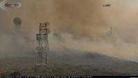
Meteorologists rely on radar to track storms. However, like any piece of technology, sometimes it has to be replaced. That’s the case with the Reno radar. The Reno radar has exceeded its lifespan of 25 years. The goal is to make the Reno radar last for another 20 years. They are replacing the pedestal. It helps rotate and position the antenna to capture data in all directions. This requires the radome, which shelters the radar, to be removed by crane. The radar tower is 80 feet tall and the dome itself is 33 feet in diameter. The radar’s different parts are extremely heavy. The image below is from 2018, during the Perry Fire. The radar is located at Virginia Peak.

With the Reno radar down, meteorologists have to look at a variety of other products. It's still possible to get a feel for the different storms, but they might have to use the Sacramento radar instead of the Reno one for storms popping up in the Sierra. The farther away the radar is, the more errors that can occur. The storms can be missed completely, or they can appear bigger than they actually are. The resolution also goes down with distance. Reno Meteorologists can also look at the Elko radar for storms farther east. But when the Reno radar is down, for the valley, meteorologists really need to look at the satellite images. Thankfully, satellites have made a lot of progress over the years. Lightning data helps too.
"We look at the temperature of the cloud tops to tell how high up the storm goes. So basically satellite and lightning for most of our area without radar,” said meteorologist Shane Snyder of the National Weather Service.
While the Reno radar itself has been here since the 90’s, the radome had to be replaced in 2008 because of wind damage. A few panels have had to be replaced because of lightning over the years as well. The Reno radar will be active again June 16th.
In the future, the Reno radar will be able to detect storms at a lower scan. For example, instead of sampling data at 7000 feet above the surface, it will be able to detect storms at 4000 feet. A radar works by sending out energy in the form of radio waves. Once the energy hits an object such as hail, rain, or snow, the energy is then scattered in different directions. Some of the energy is then reflected back to the radar.


The radar can detect how heavy the precipitation is by the amount of energy reflected back, and the distance by the time it takes for the energy to be transmitted and reflected back. Radar has come a long ways over the years. Doppler radar was invented in the late 80’s early 90’s and helps detect motion within a storm. This is crucial in times of severe weather to detect tornadoes. A Doppler radar can see energy going both away and towards the radar. When these motions are right next to each other, rotation may be present. Dual Pol radar came out several years ago and helps meteorologists see what type of precipitation is falling even better than before. The image below is from NOAA.

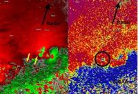
Dual Pol radars takes a look at the energy not only horizontally but vertically as well. This can help meteorologist detect hail, as well as debris being picked up by tornadoes. According to NOAA, Doppler radars transmit about 450,000 watts on average. The Reno radar transmits about 750,000 watts at its peak. A regular microwave generates about 1,000 watts of energy.