The National Weather Service in Reno has issued a
* Severe Thunderstorm Warning for...
Western Churchill County in west central Nevada...
Storey County in western Nevada...
Southern Washoe County in western Nevada...
North central Lyon County in west central Nevada...
* Until 130 PM PDT.
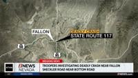
* At 100 PM PDT, a severe thunderstorm was located near Derby Dam, or
17 miles northwest of Lahontan Reservoir, moving north at 35 mph.
HAZARD...60 mph wind gusts and quarter size hail.
SOURCE...Radar indicated.
IMPACT...Hail damage to vehicles is expected. Expect wind damage
to roofs, siding, fencing and trees.
* Locations impacted include...
Fernley, Nixon, Derby Dam, Fernley - Tiger Field Airport, and
Wadsworth.
PRECAUTIONARY/PREPAREDNESS ACTIONS...
For your protection move to an interior room on the lowest floor of a
building.
&&
HAIL THREAT...RADAR INDICATED;
MAX HAIL SIZE...1.00 IN;
WIND THREAT...RADAR INDICATED;
MAX WIND GUST...60 MPH