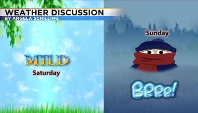

After a warm finish to the month of January, February will start out with a little bit of everything. We saw record breaking warm temperatures Saturday in the Truckee Meadows and Sunday February 2nd, 2020 will be the exact opposite. Hopefully you haven’t gotten rid of your winter coat just yet, because you will definitely need it the next few days.
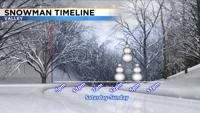
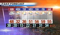
A strong cold front will move through the region beginning in the northwest side of the state by 9am and then reaching Reno by 2pm. The snow will fall both in front of and behind the front. Which means the best time to see snow will be between 2 and 4pm. The band of snow will move rather quickly and could put down 1-3” in the Sierra, and less than two inches in the valley. The snow could melt before refreezing once the sun goes down. While I don’t expect black ice to be widespread I would not be surprised for there to be some icy patches Sunday evening. The timing of this is not great with many people heading home from festivities. While the front itself is rather strong, moisture is lacking. This along with a warm ground will keep snow from really piling up. Can’t rule out a few lake effect snow showers from Pyramid and Tahoe Monday, but overall the forecast should be dry. It will be cold though.

Visibility will also be an issue when the front moves through. Winds will be strong through the evening hours with gusts in the 30’s. This is enough wind to lower visibility when the snow moves through. Winds should relax Sunday night before picking up a tad Monday. Slightly higher snow totals are expected in Winnemucca and up through Elko.

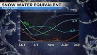
Speaking of the cold, temperatures will only be in the 30’s Monday and Tuesday. This is about ten degrees below normal. Lows will also be in the teens. Sunday will start out alright with temperatures in the 40’s, but we’ll already be in the low 30’s by 5pm in Reno. Good news if you don’t like the cold weather, cause we’ll warm up again by the later half of the week. We could use the snow though. The rest of the blog talks about where we are with our snowpack and how warm we were in January.

We’ve had some good snow seasons in the Sierra lately. Some years did better towards the end of the season, but 2016 -2017 was great pretty much all the way through. This year started off great around Thanksgiving and then it’s tapered off. Right now our snow pack snow water equivalent is about 75 percent of normal. We need the snow for the current season if we want to reach even. With that said we have a lot of water in the bank from the previous years.

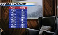
This January was the third warmest on record. The average temperature when you combine both the high and low comes to 40.8 degrees. We’ve been warmer only two other years.

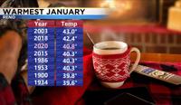
It could always be worse though right? The combined average temperature of high and lows was only 14 degrees back in 1949.

We also broke the record for today February 1st with a high of 73 degrees. The old record was 66 degrees. To give you a frame of reference the warmest January temperature ever recorded in Reno was 71 degrees. The record for February is 75 degrees. The Climate Prediction Center gives us a strong chance of having an above average month in terms of temperature and below average month in terms of precipitation. For more weather updates you can always follow me on my facebook page KTVN Angela Schilling.