Spring oftentimes brings a mixed bag of weather, with warm and cold temperatures. Snow at the end of April is not unheard of in northern Nevada, but it does not happen on a regular basis. Believe it or not, snow is likely in the Sierra this weekend, with a snow level of 5500’. A slushy inch of snow is possible in the foothills, including Virginia City. Places like Arrowcreek and the North Valleys could see a few flakes Friday night into Saturday morning, but roads will be fine. More wet weather is in the forecast through Sunday.

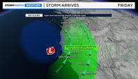
An area of low pressure located in the Gulf of Alaska will continue to stretch over the next 24 hours, forming a trough, and allowing for a secondary low to develop to the south. It is this secondary low to the south that will give northern Nevada a chance for wintry weather this weekend. Most of Thursday will be dry, with rain developing in the Truckee Meadows after dark. The rain Thursday night into Friday will be light overall, with a few pockets of heavier rain rates. A rumble of thunder is also possible. There is a better chance for scattered showers Friday afternoon.

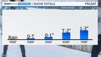
Colder air funnels in Friday night, dropping the snow level to between 5000-5500’ Saturday morning. Downtown Reno and closer to the airport will be too warm for snow, but the foothills could see some light snow accumulate on grassy areas. Especially in places like Virginia City.
Our mountain passes will be slick this weekend from sunset to sunrise, with mainly wet roads during the day. Snow will still fall from the sky above 6000’ on Saturday, but it will have a harder time sticking to the pavement because of a higher sun angle and warmer road temperature.

Snow totals will range from a few flakes at 5000’ to up to an inch in Virginia City, a couple inches at lake level, and a few inches at 7000’. The crest at Mammoth Mountain and Mt. Rose could see up to several inches of snow by Sunday afternoon.
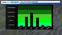
Rain totals will vary because of the showery nature of the storm, but around a third of an inch is possible in the Truckee Meadows by the end of the weekend.

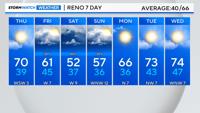
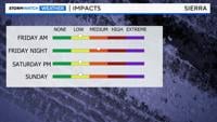
Not only will temperatures be running about 15-degrees below average on Saturday, but it also will be windy. Making it feel even colder. Wind gusts will near 50mph in the Sierra on Friday and Saturday, and 30mph in the valley. Highs will go from the lower 60’s on Friday to the lower 50’s on Saturday, and upper 50’s on Sunday.
Stay tuned for more updates.