This too shall pass… but we’re in for a round of unsettled and stormy weather through the weekend with mountains snow and (mainly) valley rain.
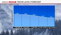
Showers and thunderstorms will be more prevalent Friday afternoon, as an area of low pressure aloft moves across the region. This will also bring snow to the mountains Friday night and into Saturday morning. A second, colder, and stronger low pressure center will move in on Saturday bringing with it the potential for heavy mountain snow Saturday and Sunday. The higher elevations along the Sierra crest will see anywhere from a foot to possibly two feet of snow.
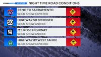
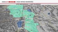
There are currently Winter Storm Warnings and Winter Storm Watches up for Lake Tahoe and the Sierra Nevada. Expect driving conditions to be difficult at times later Saturday and into Sunday morning.
This system is also much colder… and will bring a chance for some light snow to the valley floor early Sunday morning. Accumulations look to be very small… generally less than half an inch. None the less a shock to the system after our string of warm and sunny days.
The storm system exits stage right on Monday… with clearing skies and cool conditions Monday and Tuesday with morning lows in many cases dipping below the freezing mark.