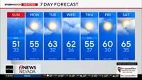
It might be the middle of April but it feels more like January in northern Nevada. Multiple storms are lined up in the Pacific, and each one will keep temperatures at bay. I wouldn’t put away your winter clothes just yet. Long term models are hinting at an active weather pattern through the end of the month. This is what we were hoping for in January, but we’ll take it now too. Skies will clear just in time for Easter, but it will be breezy with highs in the mid to upper 60’s. Making it feel a little chilly, especially in the morning. Lows will near freezing Sunday morning with clear skies, and light winds. Luckily no rain or snow will get in the way of any Easter egg hunts on Sunday, but Saturday morning will be cold with a chance for rain.

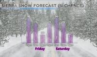
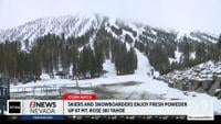
Several spots along the western Sierra have already received several inches of snow as of Thursday evening, and up to a foot of additional snow could fall by Friday morning. Especially on the western side of the Sierra. The majority of Friday will be dry with another storm moving into the region by Friday night. If you want to avoid the snow, mid morning Friday through about 4pm Friday will be the best time to travel in the Sierra. Another storm is on our heels and wont' get here until early Friday night. This strong area of low pressure is situated just west of Oregon, with a plume of moisture situated just underneath it. The jet stream is aimed at northern California allowing the snow to stay in the Sierra for now, with a sharp cut off in the valley. This is a classic example of the rain shadow effect. As the low itself drops in here from the west northwest the flow will change allowing for some of the precipitation to spill over, falling in the form of rain. Highs on Saturday will be in the upper 50’s with lows in the upper 30’s and low 40’s. The snow will be heavy in the Sierra Friday night and Saturday morning, with gusty winds and low visibility. The rain will be light to moderate in the valley, with wind gusts in the 30’s. Brrr! Anticipate delays and slow downs along our mountain passes Friday night through the first half of Saturday. Chain controls are likely early Saturday, so plan accordingly. Snow has a harder time accumulating this time of year because of a higher sun angle, but the snow will fall hard enough to cover the pavement from time to time early Friday and Friday night. Visibility will stay low throughout the duration of the storm. Snow totals will range from 4-12" Saturday morning, with a few inches possible at lake level.


We’ll get a quick break from the stormy weather on Sunday, with another storm forecasted to move in here on Tuesday, and another one next Thursday. The moisture we’ve been hoping for has finally arrived, it’s just a few months late. Highs next week will be in the 60’s with lows in the 30’s. I’d hold off on any planting for now. Both long term models, the GFS and Euro are showing an active weather pattern through the end of the month.