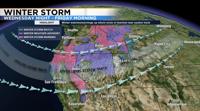
Travel is not advised in the Sierra Wednesday night through early Friday morning as a strong storm moves through the region. We finally have the combination of moisture and dynamics to get a good snow storm in the mountains.
A second storm will move through over the weekend, giving both the Sierra and valley another round of wintry weather.
A Winter Storm Warning has been posted for the Sierra beginning Wednesday night at 10pm and going through Friday morning. Friday will be sunny, but roads will still be slick Friday morning from the leftovers. A Winter Weather Advisory for the Truckee Meadows goes from Thursday at 4pm through Friday morning at 4am for slick roads and a few inches of snowfall. The hills will see 1-3 inches more snow than the airport.

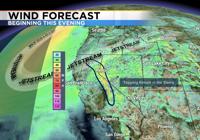
Wind speeds will be strong Wednesday night and Thursday, lowering visibility because of blowing snow. Wind gusts will range from over 70mph in the Sierra to over 30mph in the valley. Wind prone areas in the valley could see wind gusts around 60mph on Thursday as the front rolls through.


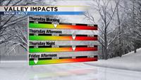
This is a fast moving storm but is capable of producing heavy amounts of snow within a short time. Snow fall rates could reach 2-4 inches per hour in the high Sierra on Thursday. It will start to snow in northeast California by early Wednesday night and expand farther south into Thursday. The snow will reach Donner Pass by 3am Thursday morning. The Thursday morning commute will be slick in spots but not widespread. There will be some shadowing to begin with, keeping the snow in the mountains. Areas north of I-80 and above 4500 feet has the best chance east of the Sierra to see snow Thursday morning.
As the front moves through Thursday afternoon, temperatures will fall below freezing, and combine with some moisture to produce snow at all elevations. Visibility will be lowered in the valley as well. The cold front and band of snow will be south of Tahoe by early Thursday night. Friday will be dry, but leftover snow and ice will make the morning commute challenging.

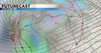
There is a good amount of confidence going into this storm with model runs continuing to show heavy snow in the mountains and some snow in the valley. Lately, the models have been showing a storm coming through a week out, then weakening as we get closer. This storm however, continues to show its strength with each model run. Each model has many members called ensembles. The majority of the ensembles from the GFS model are also showing a strong band of snow moving through on Thursday.
The window for when the front moves through is trending slightly sooner, but as of now it should move through around 4pm Thursday.

Friday is the best travel day, but it will still be sloppy Friday morning because of the leftovers. As skies clear and winds relax, freezing fog will also be a possibility. Freezing fog lowers visibility and creates a glaze on the roadways. Highs on Thursday will be in the mid 40’s on before the front moves through, but temperatures will fall below freezing by 5pm. Lows Friday morning will be in the teens. Another storm moves in over the weekend, with the worst of it Saturday night into Sunday morning.
Stay tuned for more weather updates.