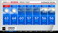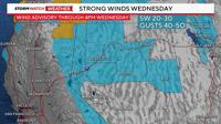
A Wind Advisory is up for much of Northern Nevada as the storm track moves further south. A cold front will move southeast today as well, kicking up our winds. There is not a significant amount of cold air with the front, but it is increasing winds speeds and allowing for some light to moderate rain.

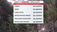
Wind gusts will range from 30-50mph in the Truckee Meadows, to over 80mph at the Sierra Crest. Wind prone areas like Washoe Valley could see wind gusts up to 70mph. The Wind Advisory goes through 4pm, as wind speeds ease towards sunset. Whenever our winds are strong, rain has a hard time spilling over. Today is the day to tie down any Christmas decorations, or they could fly away. We’ve had stronger wind events, but today will be windy enough for some travel impacts, including bumpy flights.

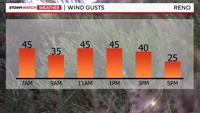
The drive home will be less windy than the drive to work, but wind speeds will pick up again around lunchtime before relaxing around 4pm. This is a weak atmospheric river, and atmospheric rivers can sometimes produce more wind than rain. Especially for the Truckee Meadows. The jet stream is moving through Northern California and is close enough to give us some rain and wind.