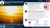
High pressure builds this week with warm and mostly calm weather conditions. We will be on a warming trend through the midweek so if you thoug…
From
To

Featured Top Story
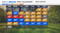
Temperatures were above normal between May 5th and May 16th, and we were below average between May 26th and May 30th.

Featured Top Story
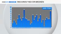
Twenty four daily records have either been tied or broken this year already, and last year at this time we only broke twelve. Majority of the …

Featured Top Story
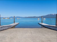
Boaters should be aware that launch docks have been removed.

Meteorology
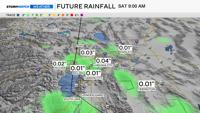
We're past the winter storm in the mountains but a few more atmospheric disturbances over the weekend will keep chances for precipitation arou…

Featured Top Story
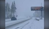
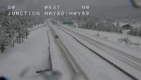
A wintry storm prompted chain controls on some mountain highways including I-80 over Donner Summit.

Featured Top Story
Snowy conditions are bringing slick conditions and chain controls to roads in the Sierra.


Featured Top Story
Lake Tahoe Unified School District says all other schools have power and will remain open as scheduled.

Featured Top Story
A stretch of June-like heat arrives this week, and it could rewrite a few records across the region.


Featured Top Story
The 2025-2026 winter season was the warmest on record in Nevada from December through February since 1895.