An area of low pressure has camped out along the Northern California coastline. Close enough to the ocean to pump in moisture and close enough to the sierra for snow. So far the Sierra has received a couple feet of snow and more is coming. The combined forecast for the Sierra is between 3-6 feet. The low won’t be out of here until Thursday.

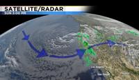
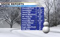
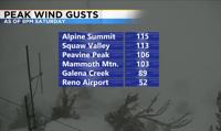
The low moves in a counter clockwise motion with snow bands moving around the low in the same direction. The Sierra gets the majority of the snow from uplift, but the valley will see at least a couple more rounds of wintry weather before the end of the week too. The best time to see snow in the valley is Sunday and Monday night. Conditions will improve during the day. The Sierra will stay a mess through Tuesday though. The snow is steady in the mountains because of uplift. The low is west of the mountains, and the flow allows the air to rise as it hits the mountains. Here’s a look at snow totals and wind reports from this weekend. Many ski resorts already got a couple feet of snow. An additional 1-2 feet is possible by Wednesday.


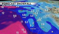
Here’s a look at forecasted snow totals through Tuesday. The valley could see a few more inches of slushy snow. Double amounts in the hills.